Showing posts with label Puget Sound recovery. Show all posts

Wednesday, November 8, 2017

Puget Sound Nutrient Watch: The Salish Sea Computer Model

Welcome to our second installment of Puget Sound Nutrient Watch, an ongoing blog series that will focus on the excess nutrient problem in Puget Sound.

In this post we will be focusing on the Salish Sea Model and how scientific computer models help us better understand the world around us.

So...what is a scientific model?

Puget Sound Model built in the 1950's at the University
of Washington School of Oceanography as a research tool
for understanding Puget Sound circulation patterns.
Many children like to play with models — like doll houses, model cars or model airplanes. These toys are simplified versions of things we find in the world around us. These models might seem like they are just amusing toys on the surface, but they actually help you learn how the world works!

Similarly, scientists also use models. Scientists often rely on developing models to establish new science. Models are ideas that scientists use to explain patterns they observe in the world.

computer model replicates some part of the environment in a way that helps us understand and predict potential changes. This allows scientists to ask the model questions like, "If the water temperature goes up three degrees, what happens to everything else?" If you were to change something in the model, it should tell you how changing the same thing in the environment would play out in nature.

Weather forecasting — for example — relies on computer models. Models are built to explain how aspects of the real world work and consist of ideas and concepts. Scientists use models to investigate the secrets of nature!

Characteristics of scientific models

Good scientific models should be:

  • Grounded in scientific principles.
  • Compared to a mechanism that is well understood.
  • Calibrated to actual data so we can have confidence in the outputs.
  • Be able to test if hypotheses are true or false.

New models are more likely to succeed if they dovetail or merge with existing scientific models. In fact — successful models often reveal that phenomena we once thought to be isolated are really connected incidents. Modern models use high-powered computers to compute millions of calculations!

It’s important to remember that a model is not the same as the real thing; they are similar in some respects, but not in all. A model becomes more refined and complex after many, many rounds of testing. Over time, the model looks less like the original simple model, and looks more like the real environment it is simulating.

We have confidence in a model's ability to simulate real life when it produces the same results that we find in actual data. If the model can accurately represent a known condition, we can use it to predict future conditions.

Why are models needed?

The most important advantage of computer modeling is that it gives us the ability to ask “what if?” questions about complex aspects of the world we can’t easily test in reality. Often, the focus of science is too small to be observed directly, or may be inaccessible for a direct visual study. For example, we may not be able to access the center of the earth to study it, but a computer model can give us a pretty good idea of what's happening!

Tidal motion in Salish Sea Model - 72-hour animation of April 2006 conditions.
Image courtesy of Pacific Northwest National Laboratory.

New scientific discoveries depend upon scientists developing scientific models and interacting with them. Each hypothesis tested, simulation ran, and calibration made helps scientists better understand nature. After all, science is an attempt to explain our natural environment and make predictions about it.

What is the Salish Sea Model?

First of all, this model covers a huge area! The Salish Sea includes the Puget Sound, the Strait of Georgia, and the Strait of Juan de Fuca.

Our Environmental Assessment Program and staff from Pacific Northwest National Laboratory (PNNL) developed the Salish Sea water quality circulation model — called the Salish Sea Model for short — as a tool to broaden our understanding of how nutrients travel and ultimately affect water quality throughout Puget Sound.

We are using the Salish Sea Model to evaluate how current and potential future inputs of nutrients effect dissolved oxygen levels in the Salish Sea.

The Salish Sea model helps us understand questions like:
  • Are human sources of nutrients in and around the Salish Sea significantly impacting water quality now? How bad might it get in the future?
  • Where are the areas that are most sensitive to human impacts? When are those effects the most harmful?
  • How much do we need to reduce human sources of nutrients to protect water quality in the Salish Sea?
Domain of Salish Sea Model.

We will be using the model to test the effects of short- and long-term actions to reduce anthropogenic — or human caused — sources of nutrients. We are aim to use this information to increase Puget Sound’s resilience to the effects of climate change and population growth. These model findings will help decision-makers use resources wisely and guide where additional study or action is necessary.

How have we used the model so far? Check out these publications:


Ask an engineer

We’ve asked one of our Salish Sea modeling engineers — Greg Pelletier — to participate in a Q&A about the Salish Sea Model, learn more from our interview!

What have we begun to learn from the Salish Sea Model?
We are starting to learn about the effect of regional anthropogenic sources of nutrients on changes in dissolved oxygen and acidification of the Salish Sea. We are finding that there are extensive areas of the Salish Sea that do not meet the water quality standards for dissolved oxygen. There are also areas where regional human-caused sources of nutrients appear to decrease dissolved oxygen to levels that do not meet the water quality standards.

How does this model help us understand ocean acidification?
The model allows us to look at how much impact is caused by regional anthropogenic sources and compared them with global sources. For example, in waters at the bottom of Puget Sound, the model predicts that the regional nutrient sources caused by humans has the highest impact when compared with estimates of combined global anthropogenic and nutrient impacts.

The model allows us to look at how much improvement would result from efforts to reduce nutrients to different levels. Also, the model allows us to look at the relationship between hypoxia (low dissolved oxygen) and acidification.


Greg Pelletier presenting at the Puget Sound Nutrient Dialogue, July 2017
How long does does it take for us to run a scenario in the model?
The model uses a very powerful “cluster” computer at Battelle’s Pacific Northwest National Laboratory. It takes a couple of days for the computer to run all of the calculations for a single year for the original version of the model, and up to three days are required for our latest expanded version of the model.

We call each model run a scenario because it represents a particular set of assumptions. For example, one scenario is the existing conditions as they are in a particular year while another scenario is what we call “reference conditions” with human sources of nutrients removed.

In addition to the computer time, it takes time to make the input files for the model scenario – and to review the input files to assure their quality, which can vary depending on the complexity of a scenario. This step alone can take multiple people and several months.

After the model run is completed, time is required to convert the model output files into visualizations such as maps or animations of the predicted water quality, interpret what they are telling us, and discuss it with project team.

What do you like most about working with models?
The best part about working with models in my job is working with all of the great people we have on our modeling team. Our modeling team from Ecology includes Anise Ahmed, Cristiana Figueroa-Kaminsky, Sheelagh McCarthy, and Teizeen Mohamedali. We also collaborate with several great people from Battelle’s Pacific Northwest National Lab. It takes a team of people to do this work.

Different people do different parts of the model analysis. For example, some people work mainly in preparing model input information, while others work more on running the model or preparing the output visualizations. The entire modeling team works together to look at and discuss the model input files and the interpret the output visualizations. It is very rewarding to find out what the model runs tell us about the relationships between nutrient loading sources and changes in water quality throughout the Salish Sea.

Another amazing thing about working with models is its ability to predict water quality in areas where we have no monitoring data. We are confident of these predictions because the model performs well to replicate observed data when we compare it to areas where we have actual water quality measurements. Sometimes the results show us where we need to collect more data.

Puget Sound, Marine Park

Our work to reduce nutrients in Puget Sound

Follow this Puget Sound Nutrient Watch blog series to stay current and learn about our work to reduce nutrients in Puget Sound.

Earlier blogs:


Visit our website and join our email list to get up-to-date information on the nutrient problem in Puget Sound. We want this to be a collaborative effort that brings all of the technical work that is happening on Puget Sound nutrients together. We need all hands on deck to find the best solutions for meeting water quality goals for Puget Sound.

By: Jenny Robertson, Ecology Environmental Specialist

Thursday, August 17, 2017

Puget Sound Nutrient Watch: A new blog series

Welcome to our first installment of “Puget Sound Nutrient Watch,” an ongoing series of blogs that will focus on the excess nutrient problem in Puget Sound.

A healthy Puget Sound is an integral part of our cultural history and future. Are nutrients causing it to change?


In this post we will be going over why we care about excess nutrients and how they are affecting Puget Sound. Read on to learn about:

  • Our recent Puget Sound Nutrient Dialogue that brought together scientists from across Puget Sound region to discuss the latest science on nutrients.
  • Why you should care. Understand what happens to a water body that is overly rich with nutrients. 
  • Two brand-new publications on nutrients in Puget Sound. These review new modules that have been added to the robust Salish Sea computer model. 
    • The report on the Sediment Diagenesis Module describes how the model incorporates the dynamic interaction of nutrients within the sediment and water column. 
    • The report on the Ocean Acidification Module reveals on how the new ocean acidification module can help us pinpoint areas in Puget Sound that are influenced the most by regional sources of nutrients.
  • How can nutrients be bad? Impacts that excess nutrients cause to the health of the Sound.
  • What to expect in this blog series.

Puget Sound Nutrient Dialogue

We would like to thank everyone that came out to the Puget Sound Nutrient Dialogue in Auburn last month, it was a great success! We had around 120 people show up ready to participate in the conversation surrounding the science of excess nutrients in Puget Sound.
Puget Sound Nutrient Dialogue participants eager to save the Sound.


If you missed out and would like to participate in future events, please sign up for email notifications through our Listserv. We welcome the opportunity to collaborate with others who value the Puget Sound and want to protect it from excess nutrients.

Presentation slides, a summary of the event, pictures, videos, and more from the Puget Sound Nutrient Dialogue will be posted on the project webpage.

Why should we care? 

Nutrients such as nitrogen, phosphorus, and organic carbon are an important part of a healthy and productive marine ecosystem. Excess nutrients, however, can be problematic for marine water quality – most often nitrogen. Just as you need nutrients to keep your body healthy, too much of anything throws the system out of balance. 

We're working to understand nutrient problems in Puget Sound
so we can keep it the beautiful natural resource that it is today. 
When it enters marine waters in excessive amounts, nitrogen causes what is called eutrophication. Eutrophication is the term for what happens when a water body becomes over-enriched with nutrients. This over-abundance of nutrients will cause dense growth of algae and plant life and the death of animal life from lack of oxygen.

Nitrogen acts like a fertilizer causing algae to grow. Too much nitrogen results in excessive algae growth, which puts the health of Puget Sound off balance. When algae die and decompose, it consumes oxygen out of the water column (especially at depth). In some shallow inlets and bays around the Sound, this will deplete oxygen to low levels which stresses fish and the other critters that live in important nearshore habitats.

Thinking about our future

Our science today tells us we have a nutrient over-enrichment problem in Puget Sound. We are in the beginning phase of a long-term project that will ultimately help us address this overabundance of nutrients. Our goal is to ensure the Puget Sound we know and love remains resilient to stresses from nutrient problems caused by our growing population and exacerbated by climate change.

Latest science – understanding the problem

Salish Sea graphic of nutrient-rich zones
from the Salish Sea Model.
One of the most important tools for understanding the effects of nutrients in Puget Sound is the Salish Sea Model. The model was developed by Pacific Northwest National Labs in collaboration with Ecology scientists and with grant funding from EPA.

This robust computer model helps us better identify human sources of nutrients that are negatively impacting the health of Puget Sound by simulating the natural environment. It models complex water circulation and water quality dynamics in all of Puget Sound, the Strait of Juan de Fuca, and the Strait of Georgia.

Our two latest publications - released July 2017 - help predict impacts that are influencing Puget Sound's health.

The Sediment Diagenesis Module added the capability to the Salish Sea Model to simulate sediment-water exchanges. This module simulates the way organic matter decomposes, which allows the model to more accurately reflect actual conditions in Puget Sound. As organic matter decays both within the water column and bottom sediment layers, nutrients are released back to the water and consume oxygen in the process.

The Ocean Acidification Module calculates the impacts of regional nutrient sources on acidification. Results from this effort indicate that human-related sources of nitrogen and organic carbon can influence Puget Sound's carbonate system balance.

Toxic algae blooms - like this one that happened at
Deception Pass - can be caused by eutrophication.

Blogging on how this issue impacts Puget Sound’s health

Throughout this series we will dive into the specific impacts caused by excessive nutrients in Puget Sound that have damaging effects on water quality.

These impacts potentially include:
  • Harming nearshore habitat and benthic invertebrates
  • Intensifying ocean acidification at some locations
  • Facilitating the break-down of the marine food web
  • Increasing the number of algae blooms
Stay tuned as upcoming blog features dig into each of these issues, highlight new reports, and share new information as it becomes available.


Tackling the Puget Sound nutrient problem

The Puget Sound Nutrient Source Reduction Project is using best available science to understand the nutrient problems in the Sound and develop a plan to reduce human impacts so that we can protect the health and resiliency of Puget Sound.

The Salish Sea Model is a state-of-the-art computer modeling tool that allows scientists, engineers, and planners to understand the complex physical, chemical, and biological patterns in circulation and water quality. We will be using the model to compare Puget Sound to marine water quality standards, understand how bad water quality will be if we continue with the status quo, and evaluate nutrient reduction options for improving and restoring the Sound to meet our water quality goals.


Visit our website and join our listserv to get up-to-date information concerning the nutrient problem in Puget Sound. You can also this full blog series by searching "Puget Sound Nutrient Watch". We want this to be a collaborative effort that brings all of the technical work that is happening on Puget Sound nutrients together. We need all hands on deck to find the best solutions for meeting water quality goals for Puget Sound.

By: Jenny Robertson, Ecology Environmental Specialist

Tuesday, June 27, 2017

Calling all lovers of the Puget Sound!

Are you interested in regional efforts to keep Puget Sound healthy and resilient? Join us in Auburn, Wed., July 19 at Green River Community College to attend our Puget Sound Nutrient Dialogue. This all-day meeting will bring together those working to understand and protect Puget Sound to discuss what we’re learning from our most recent science.

Fort Lawton West Point Lighthouse, Discovery Park, Seattle, Washington (Courtesy of Kenny Rowe)

After a decade of development, we have the state-of-the-art Salish Sea environmental computer model to help us understand changes in Puget Sound and evaluate the best solutions to reduce human impacts. This model shows us that land-based human sources of nutrients are leading to cases of low dissolved oxygen levels in the Sound. We are using this tool – in combination with ongoing field monitoring data and broad stakeholder input – to develop options to reduce nutrients in the Sound.

Join the conversation and learn how an over-abundance of nutrients affect our beloved Puget Sound. A healthy balance of nutrients is essential for a healthy food web, just as we require a balanced diet for good health. But excess nutrients from human sources can cause problems in Puget Sound just as over-eating can lead to health problems in your body. The over-enrichment of nutrients is diminishing dissolved oxygen levels that fish and other species in the Sound need to thrive.


Click here to register!

Join us in person


When
July 19 
Time
8:30 a.m. to 4 p.m. 
Where
Green River Community College, Lindbloom Student Union Center
Address

Register by July 5 to secure your seat!


Parking and the event are free. Coffee and light refreshments will be provided. Lunch will be available for purchase at the college’s newly remodeled cafeteria.


How can nutrients be negative for Puget Sound? 

A healthy Puget Sound is integral to our identity and our future. There is a growing body of science and evidence that shows increasing nutrients are adversely affecting the Sound. 

This dialogue is meant to bring together stakeholders, decision-makers, scientists, and the interested public to:
  • Talk about the current state of the knowledge
  • Discuss the effects of excess nutrients in Puget Sound
  • Make connections between different areas of research
  • Identify new studies that will improve our knowledge and understanding

Just like your human body, our Puget Sound ecosystem needs balance to be healthy. Too many nutrients in the Sound can also lead to undesirable changes in the food web, over-growths of algae that wash up on our beaches, increases in jellyfish populations, and more harmful algae blooms. Beyond changing what is considered normal for Puget Sound, these problems could reduce the Sound’s ability to be resilient to increasing pressures from climate change and the growing human population in the region.


Stay involved! 

Learn more about the project on our website where you can also find updated information on the Puget Sound Nutrient Dialogue as it becomes available.

Subscribe to our project listserv to receive email updates. 


By: Jenny Robertson, water quality environmental specialist

Tuesday, July 12, 2016

Cleaning Up: From RAGs to (environmental) riches

Ecology passes nearly 70 percent of the agency's $1.4 billion budget directly to local communities and governments.
The Port of Everett is using a Remedial Action Grant for a dredging project.

That money pays for a variety of other environmental work -- cleaning up contaminated sites, managing polluted stormwater runoff, preventing floods, managing garbage and wastewater, and more.

Remedial Action Grants, or RAGs, are significant tools for cleanups. Local governments -- port districts, cities, counties, and others -- use the grants to help reimburse some of their costs for cleaning up publicly owned properties.

Grants encourage cleanup


Cleanups aren't cheap -- they can cost tens of millions of dollars. By providing Remedial Action Grants, our Toxics Cleanup Program encourages environmental cleanup and supports local governments that want to redevelop contaminated properties they own. Funding for the grants comes from a voter-approved tax on hazardous substances as provided in the state's cleanup law, the Model Toxics Control Act.

Skagit County is using an old truck stop site for a new jail.
Without such aid, local governments might put off cleanup projects because of the expense. The grants give public entities confidence that they won't take on the entire project cost alone. (Local governments can also receive payments from former property owners or others who contributed to the pollution at a site, and from insurance policies.)

Typically, the grants reimburse 50 percent of a public entity's eligible costs. But reimbursement could go as high as 90 percent, if the local government is located in an area that's designated as "economically distressed."

Skagit County is one of the local governments using a 90 percent RAG. The county searched for a site for a new jail and eventually settled on the former Truck City truck stop site in south Mount Vernon.

Work is continuing on the new Skagit County jail.
The county bought the site in 2015. Truck City had operated for more than 30 years, with an on-site gas station, underground fuel storage tanks, truck weigh station, washing facilities, and more.

Activities at the site left pollution behind, so the county received a Remedial Action Grant to help pay for cleanup. The county's new jail is on track to open in spring 2017.

Clearing the way


Skagit County is just one example of a Remedial Action Grant in action. Dozens of the grants support projects in motion throughout the state, and helped fund completed projects.

Dredging will remove contamination around Pacific Terminal.
In Snohomish County, the Port of Everett is getting ready to start a dredging project at the former Weyerhaeuser Mill A site on Port Gardner Bay.

The dredging will remove tons of contaminated sediments from the water, plus improve navigational access to the port's Pacific TerminalThe port uses the site for handling cargo for construction and manufacturing industries, including parts for The Boeing Co.’s jetliners.

Work is expected to start in August and continue into the fall.

By Seth Preston, Toxics Cleanup Program communications manager

Friday, July 1, 2016

Around the Sound: Port Gamble Bay cleanup restarting

Cleanup, including pulling out old pilings, is restarting at Port Gamble Bay in Kitsap County.

The second round of Port Gamble Bay cleanup is gearing up.

Contractors are already setting up and starting some preliminary work, like stockpiling capping materials and pulling out pilings, as they prepare for the second year of cleanup work. This phase of cleanup will run through January 2017. It  follows the work that occurred from fall 2015 through January 2016.

The cleanup is focusing on chemical contamination and wood waste left by more than a century of industrial activities. From 1853 to 1995, the Pope & Talbot sawmill operated on the shores of the bay. After the mill closed, the company's resources were acquired by current site owner Pope Resources. The site was used for handling, sorting and storing logs and materials.

Port Gamble Bay is identified as one of several priority areas under the Puget Sound Initiative, which is an effort to improve and restore the Sound's health and habitat.

Pope Resources is responsible for the cleanup, under the oversight of Ecology's Toxics Cleanup Program.


What's happening


The summer months of the construction season will be focused on pile pulling, demolishing old structures and using about 33,000 cubic yards of clean material to cap a 61‐acre area in the central bay south of the former mill site. Bank excavation and debris removal are also planned.

Piling and dock removal at the former log transfer facility is scheduled to start July 18. A small area within the Port Gamble Forest Heritage Park -- the park access point  and parking adjacent to the shoreline (south and east of the trail access parking) -- will close for about three weeks. A sign is posted. The upland trails will remain open.

In the fall and winter months, dredging and follow‐up capping will move into high gear. Work will move from south of the mill site to north of the mill site as the season progresses.

Watch for heavy truck traffic if you're visiting or passing through Port Gamble. And the mill site will be closed to the public because of construction hazards.


What's been done


Within the first year, cleanup crews:
  • Removed 3,312 pilings.
  • Excavated 19,098 cubic yards of intertidal sediments.
  • Dredged 22,360 cubic yards.
  • Removed and recycled 3,063 tons of steel, concrete and other debris.
  • Delivered 69,051 tons of clean capping and habitat materials.

Once finished, cleanup will have removed about 6,000 creosote pilings and overwater structures, excavated roughly 70,000 cubic yards of contaminated sediment and wood waste, and sand capped other wood waste areas.


Stay informed


Weekly construction updates and more information can be found online.

By Seth Preston, Toxics Cleanup Program communications manager

Thursday, July 23, 2015

Around the Sound: A great day at the bay!

By Seth Preston, communications manager, Toxics Cleanup Program

Thursday was a powerful day at Port Gamble Bay.

Port Gamble S'Klallam Tribal Chairman Jeromy Sullivan
The Port Gamble S'Klallam Tribe held an amazing blessing ceremony today for a coming, major cleanup of in-water sediments in the bay. The tribe has lived on the bay's shores for generations, and will for generations to come. It is their heritage.

Today's ceremony was held on the former Pope & Talbot mill site. The mill operated in and around the bay for over 140 years, and left a legacy of pollution. And now it's time to clean up that contamination.

Lots of thanks


Canoe team members prepare to leave the ceremony.
Current mill site owner Pope Resources is the main responsible party and will pay for the cleanup work. The company has stepped up, and current President and CEO Tom Ringo spoke about how committed his company is to the cleanup.

Public Lands Commissioner Peter Goldmark, who helms the Department of Natural of Resources, talked about how the Port Gamble Bay cleanup is not only important for the local community, it is an example of all the good work being done to clean up and restore Puget Sound as a whole.

Ecology's site manager for this project, Russ McMillan, talked about the great partnerships that are making this cleanup happen.

Tribal members serenade and salute the canoe team.

Lots of meaning


Port Gamble S'Klallam Tribal Chairman Jeromy Sullivan and Suquamish Tribal Chairman Leonard Forsman spoke from their hearts about how much this cleanup means to them, their people and the local environment.

And it means much to all of us who care about Washington's resources, the Sound and all of its waters that help define our quality of life.

Thursday, May 21, 2015

Around the Sound: Moving ahead in Port Gamble

By Seth Preston, communications manager, Toxics Cleanup Program

We're getting ready to launch a major cleanup in Port Gamble Bay in the coming weeks and months.

The Pope & Talbot mill in 1940.
The bay is a high priority under the Puget Sound Initiative. We and various partners are already doing restoration and preservation work in and around the bay, so this cleanup project is the next step.

The mill site in an old aerial view ...
Historical activities at the former Pope & Talbot mill site released contamination and wood waste on land and in the water. The mill operated for more than 140 years before closing in 1995. Since then, the site has been used for various activities.

The cleanup work will be the topic of a public meeting on May 27 at the Hood Canal Pavilion, 4740 NE View Drive, in Port Gamble. An open house will begin at 4:30 p.m., followed by a presentation and discussion that will start at 6 p.m.

Come join us!


... and in a more recent photo after the mill was removed.


Thursday, April 23, 2015

Around the Sound: Another Anacortes site cleaned up

By Seth Preston, communications manager, Toxics Cleanup Program

Our Puget Sound Initiative work in the Anacortes area has drawn a lot of attention from community members and local media.

Those projects generally involve large, complex, high-profile sites like the former Scott Paper mill site and the old Custom Plywood site.

Wyman's Marina structures before removal.
But through our work with the Port of Anacortes and other site owners, we're also helping to address issues at smaller contaminated properties.

Take, for example, the old Wyman's Marina and Wholesale Supply site. We're taking comments until May 19 on our proposal to declare the site to be cleaned up.

From taking care of boats ...


Prior to the late 1940s, the site and surrounding area were used for lumber milling and shipbuilding operations. The property was sold and was used for an 80-berth marina with fueling, dry dock, and maintenance and storage facilities. The marina provided boat maintenance and engineer repair services. 

In 1965, the port bought the property, then leased it to new operators who continued boat repair and fueling services.

The marina operated until 1998, when boat maintenance operations and all underground storage tanks associated with marine fueling were decommissioned and removed.

The past operations contaminated the site with petroleum-related substances, metals and pesticides.

... to helping salmon


The port has removed all structures in water and on land, plus more than 400 tons of contaminated soil.

Now the site has been converted into habitat for juvenile salmon. Nearly 18,000 square feet of intertidal habitat and 8,500 square feet of riparian/salt marsh habitat were created.

It's not as big as those old mill sites, but it's yet another step toward improving and preserving our environment ... and our Earth.

Wednesday, March 25, 2015

Around the Sound: Reaching out in Everett

By Darrah Johnson, education & outreach specialist, Toxics Cleanup Program

Darrah and Andy in Everett (photo by Andrea Matzke).
We have a lot of cleanup activity coming up in Everett’s Port Gardner Bay, so the Toxics Cleanup Program wants to make sure local residents have plenty of opportunities to find out what’s going on.

On Saturday, March 21, baywide cleanup coordinator Andy Kallus and I talked with kids, parents and community members about our Puget Sound Initiative work in Everett. The SnoCo Together Community Skills Fair, a free event at Evergreen Middle School, was hosted by Transition Port Gardner, Futurewise, WSU Extension, the city of Everett, and Northwest Center for Alternatives to Pesticides.

The event’s goal was to inform the public about the 11 Puget Sound Initiative sites around Everett’s Port Garden Bay. Specifically, the goal was to reach out to populations that may not be adequately engaged with traditional outreach strategies.

Cleanup on Everett's waterfront


Ecology identified Port Gardner Bay as a high-priority bay under the Puget Sound Initiative. An Ecology team works with the Port of Everett, other site owners, area tribes, and other stakeholders to help shape cleanups at waterfront-area cleanup sites.
Dredging at Everett Shipyard in December 2014.

We may have up to eight public comment periods in the next several months for various steps in our cleanup process. (Stay tuned as those take shape.)

On Saturday, Andy and I talked with between 30 and 40 people who expressed varying levels of interest. Some were able to find their houses on the baywide map displayed, had personal connections to the industrial companies formerly operating at the sites, or wanted a closer look at some of the historical images in our slideshow.

And 'The Galloping Gourmet', too!


As a fun bonus, the keynote presenter was Graham Kerr, best known as the star of “The Galloping Gourmet.” His speech emphasized the need for greater social awareness and engagement to protect the environment.

His most recent trilogy of books compares the life cycle of the Chinook salmon to his own life, and more broadly to the human condition and the current state of the environment. It is titled “Flash of Silver,” referencing the shimmer made by a fish that has overcome an obstacle.

As one in the school overcomes an obstacle, the others see their own glimmer of hope and know that there’s a way to get to where they need to be. The metaphor applies to current issues of climate change and source control.

In addition to Kerr, the event also featured booths, workshops and a variety of youth performances.  

Wednesday, February 25, 2015

Around the Sound: Custom work earns kudos

By Seth Preston, communications manager, Toxics Cleanup Program

The stunning transformation of a toxic old mill site in Anacortes is getting some well-deserved attention, and not just from community members.

The American Council of Engineering Companies (ACEC) of Washington recently presented a "Best in State" Gold Award for the Custom Plywood mill cleanup to consulting firm Hart Crowser and our Anacortes/Fidalgo Bay team in the Toxics Cleanup Program. The award was in the Social/Economic Sustainability category.

Ecology team members were (from left to right) Arianne Fernandez, Pete Adolphson, Hun Seak Park, and Sandra Caldwell.

Custom Plywood is one of several sites in the Anacortes area  that is being cleaned up under the Puget Sound Initiative.

From toxic to terrific

The Custom Plywood site in July 2013 ...

The mill site had been used for heavy industry since the late 1800s. After a 1992 fire destroyed the closed mill, broken concrete and twisted rebar littered the site. Soil contained heavy metals and petroleum products. 

Groundwater beneath the site was contaminated. Dioxins and wood debris smothered marine sediments. Old pilings coated with toxic creosote and the remains of old structures slowly deteriorated in the bay. 


In 2011, TCP led a cleanup of the site's 6 uplands acres. Contractors removed pilings and structures from the land, and dug up about 33,600 tons of contaminated soil. They brought in about 39,000 tons of clean soil to rebuild the land.
... and in May 2014.

In 2013, cleanup focused on the shore and in-water issues. About 1,450 old pilings and 7,000 tons of fired-damaged structures and materials over the water were removed. About 8 acres of in-water sediment contaminated with dioxins and wood debris were dug up.

Fidalgo Bay was connected to a wetland area created in 2011. A jetty was extended and a new spit was added to prevent waves from eroding the shoreline. And the shoreline was almost tripled in length.


Environment, economy, community


Custom Plywood is another example of how cleanup work can benefit the environment, the economy and the community. Cleanup puts people to work, which provides for an immediate economic benefit because construction crews spend money in the local area. Cleanup clears the way for future economic activity.

Cleanup improves and protects the environment, which also protects the health of local residents. And communities benefit from economic opportunities and an improved quality of life.

Monday, October 6, 2014

Around the Sound: Pier today, gone tomorrow

By Seth Preston, communications manager, Toxics Cleanup Program

From this ... 
Our restoration work keeps rolling along in and around Port Gamble Bay.

Thanks to the Legislature, we were able to contract with the Port Gamble S'Klallam Tribe to remove the old, deteriorating Point Julia pier, as well as in-water and on-shore debris. That debris includes things like rotting boat hulls and abandoned nets. (More on that in a future ECOconnect post.)

Thursday, August 14, 2014

Around the Sound: Bringing back the oysters

By Seth Preston, communications manager, Toxics Cleanup Program

Staff and volunteers for the non-profit Puget Sound Restoration Fund took to the water recently to boost the Olympia oyster population in Port Gamble Bay.

A volunteer washes oyster shells into the bay.
It's part of Ecology's work to restore and preserve the Kitsap County bay, a key cleanup area for the Toxics Cleanup Program under the Puget Sound Initiative. Port Gamble Bay and its shores, like other former and current "working waterfronts" around the Sound, are polluted from large historical industrial operations -- in this case, from a large sawmill that operated for roughly 140 years.

The Puget Sound Restoration Fund spread oyster shells to provide a base for reviving the Olympia oyster population in the bay, which will support restoration of Washington's only native oyster.

Other restoration and preservation work in Port Gamble Bay includes:
  • Removing creosote-treated pilings at Point Julia, Martha John Estuary and other locations.
  • Studying the reasons why herring populations have slumped badly in Port Gamble Bay, as they have in other parts of the Sound.
  • Revitalizing riparian vegetation along the shores and eelgrass in the water to support fish, birds and other organisms.

Not their first rodeo

Oyster shells are used to help revive oyster populations.
This was not the first time the Restoration Fund folks have tackled a shellfish project. They spread 200 cubic yards of oyster shells in Skagit County's Fidalgo Bay, thanks to funding Ecology secured through a Natural Resource Damage Assessment and Restoration settlement tied to the former Scott Paper mill.

The Port Gamble effort, however, is on a much larger scale -- staff and volunteers spread 1,500 cubic yards of oyster shells.

We will be watching to see what happens next.

Cleanup also coming

At the same time, we're continuing to work with Pope Resources to design a cleanup of pollution caused by historical operations at the old Pope & Talbot forest products mill on the bay. The mill operated from 1853 to 1995 before closing.

We are on target for in-water cleanup work to start in summer 2015.

Thursday, June 19, 2014

Around the Sound: Cleanup poised to start at Budd Inlet site

By Seth Preston, communications manager, Toxics Cleanup Program

The former Reliable Steel manufacturing facility on Olympia's Budd Inlet is almost ready for a partial makeover.

Aerial view of Reliable Steel. (Ecology photo)
We're asking the public to comment on a proposed plan for doing some cleanup work at the site starting in August or September.

What we're planning
The work is going to include digging up and removing contaminated soil, metal debris, and an underground storage tank that's leaking heating oil.

The work will be focused on two parts of the site, making this an "interim" or partial cleanup. More work will need to be done at some future point.

Saving Puget Sound
Boat building, steel fabrication and welding took place at the site starting in 1941. Historical operations left behind environmental contamination, including heavy metals, petroleum hydrocarbons and other pollutants in soil and groundwater.

Reliable Steel in 1955. (Photo courtesy of Squaxin Island Tribe)
The facility shut down in 2009, and a fire in 2010 badly damaged some of the buildings. Two buildings were torn down in 2011.

Reliable Steel is one of seven sites in and around Budd Inlet being cleaned up under the Puget Sound Initiative. We're also working with the Port of Olympia to study and clean up contaminated sediments in the inlet.

Monday, June 16, 2014

Ferries for Science: Technology hitches a ride to better understand Puget Sound

By Sandy Howard, Department of Ecology; Broch Bender, Washington State Ferries; Hannah Hickey, University of Washington

The Washington state ferry "Salish."
To improve our understanding of Puget Sound and our ability to keep it healthy, state marine scientists have collaborated to install a high tech water monitoring sensor on the hull of the 64-car Salish that makes daily crossings between Port Townsend and Coupeville.

“Monitoring of Puget Sound is important because it helps us understand long-term trends and changes over time,” said Carol Maloy, Department of Ecology marine scientist. “Monitoring helps us separate if changes are natural or human-caused. If changes are human caused, perhaps there are steps we can take to reverse the problems.” 

This poster will soon be hung inside the ferry
for passengers to read.
The ferry sensor measures how fast the water, from surface to sea floor, is moving. It also measures the direction the water is moving.

Scientists intentionally chose Admiralty Reach, the stretch of water across the mouth of Puget Sound, where the ocean water comes in and the fresh water moves out to sea. The narrow constriction point between the Strait of Juan de Fuca and Puget Sound is a relatively shallow bottleneck and makes it a good place to measure water exchange and circulation between Puget Sound and the Pacific Ocean.

The water velocity information will help scientists understand how much Puget Sound is influenced by the ocean. In particular, they hope it gives them a handle on how much low-oxygen water and corrosive water with very low pH may be coming into Puget Sound from the ocean.

Low-oxygen water is a problem because aquatic life needs oxygen to thrive. Aquatic life can also be sensitive to low pH. The information will also help scientists understand nutrients and algae blooms. This testing will increase understanding about the transport of toxic chemicals and ocean acidification.

Creative and cost effective

“This is a great example of a creative and cost-effective collaboration that will help us better understand the complex marine ecosystem of Puget Sound,” said Ken Dzinbal of the Puget Sound Partnership.

Jim Thomson, principal oceanographer at the University of Washington Applied PhysicsLaboratory added, “The Port Townsend-Coupeville ferry makes multiple runs per day, so this gives us unprecedented, continuous monitoring data that we’ve never had before.

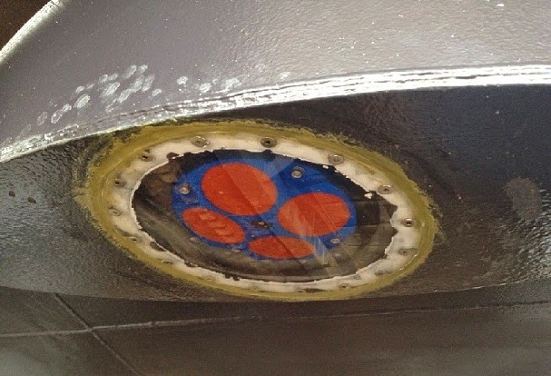
The Acoustic Doppler Current Profiler as it looks installed
in the hull of the Washington State Ferry "Salish."

How do the sensors work?

The sensors are called Acoustic Doppler Current Profilers, or ADCPs. They send tiny sound waves (pings) down through the water column beneath the ferry as it is underway.  The technology is very similar to the ‘depth sounders’ and ‘fish finders’ used on many recreational vessels.

Particles in the water column reflect the sound back. The time it takes for the echoes to return to the ADCP is used to calculate the distance beneath the ship, and the Doppler shift of the ping is used to calculate speed and direction (velocity) of the water flowing under the ferry. Soon the sister ferry Kennewick will also be outfitted with the sensor.

Innovation began in 2009 with Clipper Navigation, Inc.

The state’s innovation began in 2009, when the Department of Ecology gained permission to install oceanographic sensors on the private passenger ferry Victoria Clipper IV  that transits between Seattle and Victoria.

The sensors measure phytoplankton concentrations, turbidity, freshwater influence, salinity, and water temperatures during the ferry's twice-daily runs.

Now in the program’s fifth year, the Victoria Clipper monitoring program is helping us better understand algae blooms, plankton food web interactions, river plumes, and changes over time in Puget Sound. “We thank the operators of the Victoria Clipper for generously working with us – it’s been a great partnership that continues,” Maloy said.

Location on ferry of the acoustic doppler current profiler
Funding for the project came from the EPA’s National Estuary Program, which identifies, restores, and protects significant estuaries of the United States, including Puget Sound. Projects are focused on taking action to protect Puget Sound.

Project partners include the Washington Department of Ecology, the University of Washington Applied Physics Laboratory, Clipper Navigation, Inc., Washington State Ferries, the Puget Sound Partnership, the U.S. Environmental Protection Agency (EPA) and Integral Consulting, Inc.

View a video about the Washington State Ferries sensor and a poster of how the science works at http://www.apl.washington.edu/project/project.php?id=ferries_for_science.