Showing posts with label Columbia River. Show all posts

Thursday, September 12, 2019

How woody debris becomes orca food

Southern Resident killer whales feed on Chinook salmon that rely

on degrading logs for spawning in the Yakima Basin floodplains


Last month, I was lucky enough to tag along with a large group of Yakima River Basin stakeholders to witness firsthand a massive floodplain restoration project in the Teanaway Community Forest that will benefit Southern Resident orcas.

As we arrived at the first staging area, the sounds of a tandem rotor helicopter could be heard long before we could see it. Looking in the direction of the sound, I saw a bundle of large tree trunks lifted into the sky, on their way to their new home in the Teanaway River.

“Why on earth are we dumping logs into a waterway? " you may ask. "And what does this have to do with our Southern Resident Killer Whales?”

Well, let's look at the Southern Resident killer whales and their diet.
   

Orcas feed at Columbia River mouth


Our resident orcas hunt near the mouth of the Columbia River from January to April, which just happens to be the same time spring Chinook are schooling for their upstream migration to their spawning grounds high in the Cascades.

The Chinook’s large size and high fat content provide orcas with the high calories vital to maintaining their health and replenish fat reserves that will get them through leaner times.

Spring Chinook and other salmon species begin their life in streams and rivers that provide clean and cool water spawning grounds. This important habitat is found throughout the Columbia River Basin, including the Teanaway River and its tributaries in the Yakima River Basin.

However, Chinook numbers are in peril. Along with  the overall declining numbers of salmon species, the orcas' food source is becoming scarcer and scarcer. The survival and recovery of our resident orca population hinges on an adequate source of food available year round.


Orca feeds on Chinook salmon (Photo by John Durban (NOAA Fisheries/Southwest Fisheries Science Center)


The Yakima Basin Integrated Plan and the Teanaway Community Forest


For over a century, loggers and settlers in the Teanaway altered the landscape to meet their needs. This included the removal of woody debris from these waterways to allow for the easy transportation of timber downstream. Their actions degraded floodplains, reduced channel diversity, increased stream incisement, and devastated vital spawning and rearing habitat for both anadromous and resident fish.

In 2013, the legislature appropriated funds for the state to purchase the 50,000-plus acres in the Teanaway from a private landowner. That same year, the Teanaway was designated as the first community forest in the state. Community forests are managed not only for habitat restoration, conservation, and preservation, but also as a sustainable working forest.

As a sustainable working forest, grazing, logging, and recreational opportunities are overseen in a way to avoid critical habitats and restoration areas, while maintaining a healthy ecosystem. Restoration of both upland and aquatic habitat, as outlined in the Teanaway Community Forest Management Plan, is key to restoring the Teanaway’s overall health. This includes floodplains.

By restoring the floodplain, we are also restoring both aquatic and surrounding upland habitats. Flood events are when the magic happens.
During flood events, the logs and root wads placed in strategic locations slow streamflows by forcing the water to move over the wide and flat adjacent floodplain. As the water spreads across the floodplain, it puts its habitat enhancing powers to work.

Floodplains not only help control streamflows during flood events, they also:
  • Act as a sponge to refresh the groundwater table
  • Provide resting pools for fish
  • Increase stream channel diversity
  • Reduce flood damage risks downstream
  • Create and maintain vital spawning and rearing habitat for spring Chinook and other anadromous and resident fish

The Tour


Inspecting Jungle Creek we got a close up look at what appeared to be a healthy stream, with its crystal clear water and a streambed lined with large beautifully rounded rocks. However, its appearance was deceptive of its true health, according to our tour guide, Scott Nicolai with the Yakama Nation. He explained how despite the looks of the stream, it is actually degraded to the point that fish can no longer be supported.

“It’s important to recognize that we are only giving the stream what it needs to recover from decades of degradation, the stream does the rest of the restoration itself (during high flows),” Nicolai said.

Large wood, placed in Jack Creek in 2012.
Our next stop was at nearby Jack Creek where large logs have already been placed in the stream. This gave us an idea of what Jungle Creek and other creeks will look like once they've been restored with logs and woody debris. The first thing I noticed was how the logs looked like they were always a part of the landscape, blending in easily with the surrounding habitat.

We are eager to see the results of the Jack Creek floodplain restoration once a large flood event occurs.


Project Sites


In 2018, the Teanaway Floodplain Restoration project restored approximately 150 acres of floodplains by placing more than 5,500 logs in 8 miles of Teanaway tributaries including:
  • Jungle Creek
  • Rye Creek
  • Lick Creek
  • Indian Creek
  • Middle Creek
  • Dickey Creek
  • First Creek
  • Carlson Creek
This year, logs and root wads were placed in approximately three miles on the North Fork Teanaway. We anticipate additional large wood floodplain restoration work to continue in 2020. Additional Floodplain Restoration project sites outside of the Teanaway Community Forest will place over 5,400 logs in 24 miles of creeks and rivers including:

  • Swauk Creek
  • Umtanum Creek
  • North Fork Manastash Creek
  • Little Naches River
  • Little Rattlesnake Creek
  • Satus Creek

In addition to the Teanaway Floodplain Restoration project, the Yakima Basin Integrated Plan supports a wide variety of projects benefiting the farms, families and fish of the Yakima River Basin including our fish passage project at Cle Elum Dam and the Kachess Drought Relief Pumping Plant water supply project. For additional information regarding the Yakima Basin Integrated Plan, please visit our Department of Ecology website.

For more information regarding the Yakama Nation Fisheries Floodplain Restoration project, please visit their website, or contact Scott Nicolai, project manager, at nics@yakamafish-nsn.gov.


Some factoids


  • More than 80 percent of the Southern Resident orcas' diet consists of Chinook salmon
  • The average orca must consume 18-25 adult salmon daily just to meet its energy requirements
  • The Southern Resident population must catch a minimum of 1,400 salmon daily to sustain their calorie needs, which adds up to at least half a million salmon a year
  • For the population to grow to 140 whales, an allowance of one million salmon a year is required
  • Female salmon lay 2,000 to 10,000 eggs; less than one percent survive and return to their spawning grounds to produce the next generation.


By Jennifer Stephens, Environmental Specialist, Office of Columbia River

Wednesday, December 6, 2017

Protecting our great Columbia River

Bulk cargo ships at anchor in Astoria, Oregon. Photo courtesy of  Alex 
Butterfield, CC BY 2.0.
Was the mighty Columbia River created by volcanoes, floods and earthquakes, or was it created by Coyote, who according to tribal legend, realized that there were salmon in the ocean and that people needed to eat them?

Did Coyote stage a large battle with a great beaver, backing the beaver up into the Cascade Mountains, where the beaver tail scraped out the Columbia River Gorge? Is this what opened up a channel from the ocean to bring the salmon to the people?

This tribal legend told in oral tradition, taken from a Northwest Power and Conservation Council Columbia River history report, is just one example of the rich cultural lore associated with the river.

Today, the river is this and a whole lot more. It’s a vital shipping corridor that benefits both Washington and Oregon, and our regional and international economies.

Keeping an eye on vessel traffic


Here at the Department of Ecology, we are watching vessel traffic on the river with an eye to protect it from oil spills.

Each year, hundreds of oil-carrying vessels enter the Columbia River to deliver more than a billion gallons of gasoline, jet fuel, and other petroleum products to ports in Washington and Oregon.

Chemical tanker heading to sea from the mouth of the Columbia River. Photo 
courtesy of Bruce Fingerhood, CC BY 2.0.
The river is a busy corridor. Oil-carrying tankers and barges share space with cargo ships, passenger vessels, recreational boats, and fishing vessels.

A big oil spill could not only harm the river, its shorelines, and the fish and animals that depend on the Columbia’s waters, it could also impact both states’ economies. The river could be closed to vessels that deliver goods and services to communities along the river, interrupting the region’s export of grain and other farm products.

A spill could threaten both Washington’s and Oregon’s rich cultural and historic resources that lie along this vital corridor. Based on 2006 numbers, a large spill could cost Washington $10.8 billion and 165,147 jobs.

Many hands help keep the river safe from vessel mishaps. They include the Lower Columbia Region Harbor Safety committee, the Northwest Area Committee, the Sector Columbia River Area Maritime Security Committee, the Oregon Board of Maritime Pilots, and the U.S Coast Guard.

We recently worked with them all to complete a just-out report on Columbia River vessel traffic safety for the Washington Legislature.

A key finding is an obvious point – while the likelihood of a major oil spill on the Columbia River is low, the consequences are high to both Washington and Oregon.

Why we did the evaluation


As our energy picture changes, new oil-handling projects may come online that would increase the number of oil tankers transiting the river. Concerned about the potential increased risk of spills, the Washington Legislature directed us in 2015 to assess vessel traffic management and safety within and near the mouth of the Columbia River to determine:

• The need for tug escorts for vessels transporting oil as cargo
• Tug capabilities to ensure safe escort
• The highest level of protection that can be attained using technology, staffing, training, operational methods, while considering cost and achievability.

Spill prevention is a collaborative effort


Our evaluation showed us that the river has a robust set of safety standards already in place to reduce the risks of accidents and oil spills, but that more could be done to ensure we’re prepared should worst come to worst. Some of these safety measures are mandated by state and federal laws and regulations, while others are voluntary. For example, all tank vessels operating on the Columbia are required to have double hulls, reducing the likelihood of spills from collisions and groundings, but if tanker traffic increases, tug escorts could provide added protection to reduce oil spill risks.

Many partners participated as we conducted the evaluation, and together we generated a common framework for understanding oil spill risks and identifying potential risk reduction measures. A key recommendation in the report is that existing collaborative maritime safety programs are our best opportunity to prevent oil spills on the river and bar.

Keeping our spill prevention safety net strong


The safety evaluation is a valuable step in protecting both Washington and Oregon against future oil spills. The river is valuable and worthy of our attention. Just ask Coyote, the beaver, the salmon, and the people.

Read the full report online, access a brief focus sheet, and find additional information about our risk assessment work on our website.


By Sandy Howard, Spills Program

Tuesday, October 18, 2016

Reynolds Smelter Cleanup/Millennium Bulk Terminals - Longview Update


There’s a lot happening at the former Reynolds smelter site in Cowlitz County’s industrial area this autumn. Some of it will be tangible, boots-on-the-ground work, but there’s also a tremendous amount going on behind the scenes. Although cleanup of the site and redevelopment are on separate regulatory paths, parallel progress is being made.

First an overview of what’s up with the site cleanup, then an outline of what’s happening with environmental reviews related to coal export proposed by Millennium Bulk Terminals – Longview.

Cleanup Action Plan

For almost three-quarters of a century, the site of the former Reynolds Metals Reduction Plant in Longview has hosted intense industrial activity. For 70 years, this property was an active aluminum smelter and continued to receive bulk shipments of alumina after the smelter closed in 2001. The ore continued on to a Wenatchee smelter.

For the past decade, most of activity at the site has centered on understanding and developing options for cleaning up the chemical contamination and waste byproducts left behind by the operations of the first 70 years. While working alongside the local community, property owners and Cowlitz County, the Department of Ecology has carried out a regulatory oversight role ensuring future cleanup will meet strict legal standards that protect people and the environment.

Rigorous studies and sampling of the site identified soils with elevated levels of fluoride, polycyclic aromatic hydrocarbons (PAHs) and total petroleum hydrocarbons. Testing has shown that the shallow groundwater at the site contains fluoride and PAHs.

The importance of cleaning up this site to the local community is reflected by the robust public engagement during the cleanup process. This includes local leaders, community members, tribal governments, the property owner Northwest Alloys, Inc., and Millennium, which leases the property. As a result, this complex cleanup is well-informed and comprehensive, as outlined in the draft Cleanup Action Plan, which Ecology expects to finalize later this year.

A thorough cleanup of this site is a high priority for everyone. Northwest Alloys, Inc., and Millennium are responsible for funding the cleanup. Once the final Cleanup Action Plan is issued and a legal Consent Decree is signed, cleanup can begin.

Columbia River Sediment Dredging

While investigating the site, Ecology found contamination in nearby Columbia River sediments. A small area of sediment is contaminated with PAHs.

In November, this pocket of pollution is scheduled to be dredged and sent to a landfill licensed to accept contaminated sediments. More information about the early dredging action is outlined in an approved interim cleanup work plan.

Clean, sandy backfill will replace the material that is removed.

Millennium Bulk Terminals-Longview Environmental Review

Separate and distinct from the site cleanup, Millennium is proposing to build and operate a coal export terminal on a portion of the site. Before any permit decisions can be made, Cowlitz County, Ecology and the U.S. Army Corps of Engineers must complete federal and local environmental studies.

The federal study is led by the Army Corps of Engineers and follows the National Environmental Policy Act (NEPA). The local study is being co-led by Cowlitz County and Ecology and follows the State Environmental Policy Act (SEPA). The two studies are on different timelines and both are required before local, state and federal permit decisions can be made.

Final SEPA EIS planned for Spring

The SEPA final Environmental Impact Statement (EIS) is a much-anticipated project milestone. After three public hearings that drew hundreds of people and an unprecedented 267,000 public comments, the draft study requires significant additional work before issuing it in a final form.

Cowlitz County and Ecology announced that they plan to release the final SEPA EIS on April 29, 2017, four months ahead of schedule.

NEPA Draft EIS Out for Public Review

On Sept. 30, the U.S. Army Corps of Engineers issued its draft EIS for the federal review required by NEPA. The 60-day public comment period on the federal draft study continues until Nov. 29. More information is available at the Millennium Bulk Terminals NEPA Draft EIS webpage.

There are also public comment periods for two federal permits related to the proposed coal export terminal that continue through Nov. 29. Read the joint public notice.

Recap

Cleaning up legacy pollution from large industrial sites is a big deal for any Washington community. For the Longview-Kelso region, the cleanup and redevelopment of the old Reynolds smelter offers important economic opportunities, and a chance to reclaim a contaminated site.

Cowlitz County and Ecology continue to ensure activities at the site, whether they are related to cleanup or a future use, are meeting local and state requirements.

Back in 1941, when the Reynolds smelter was manufacturing aluminum to build aircraft for the war effort, it’s unlikely that anyone imagined what the future of this site held; both the immense effort required to clean up the site, and the equally immense efforts from people of all walks of life to influence its future.

One thing is for sure: there is a lot of activity on the site. It’s a flurry of activity and it’s not even winter, and there’s much more happening in the months ahead.

By: Dave Bennett, Southwest Region communications manager


Monday, March 9, 2015

Southwest Washington smelt run

By Chase Gallagher, Communications Manager Southwest Regional Office

In Southwest Washington, this year’s smelt run is causing a bit of a splash in the area’s rivers. As thousands of the small fish return to spawn, the circle of life completes and their bodies wash-up along the river’s shore.

A smelt completing the circle of life in the Columbia River.

As their bodies decompose, the smelt’s oil is released into the water, creating an oil sheen that to the untrained eye looks a lot like a hazardous spill. Our spills response teams received a number of calls last weekend about oil sheens in area rivers, but all evidence pointed to the smelt as the culprit.

The story behind every sheen


With smelt bodies along the shore, tracking the source of the oil sheen can sometimes be simple. But the river’s flow may also carry the oil downstream farther than the smelt bodies on shore, making it harder to identify. On close observation however, the smelt oil contains tiny scales, which can help guide our responders in determining the appropriate action.

While this die-off is nothing new, our unseasonably nice weather may be bringing more people outside, causing an increase in people witnessing the natural life cycle, and in turn creating an increase in calls to our spill responders.

Of course, humans aren't the only ones taking notice of the smelt:
It’s always important for our crews to assess and identify the source of any spill, whether from people or fish. Contact us to report a spill when you’re out and about, and together we can make sure we’re all doing our part to protect our waters.

Tuesday, December 30, 2014

Cleaning Up: How dredging is cleaning up Ridgefield’s Lake River

By Joyce Mercuri, Diana Smith, and Craig Rankine, Toxics Cleanup Program

How do you remove toxics from a sensitive environment, including a national wildlife refuge? This year, Ecology and the Port of Ridgefield have been using advanced cleanup techniques to remove pollution at the Pacific WoodTreating (PWT) cleanup site.

Recently, work shifted from Carty Lake to Lake River. The Carty Lake cleanup was finished in late October (learn more here and below). Meanwhile, the port’s contractor started cleaning up Lake River sediments in late October.

PWT’s operations polluted Lake River sediments near the port property with dioxins, pentachlorophenol (PCP), cresols, and polycyclic aromatic hydrocarbons (PAHs). Dioxin is the main contaminant of concern.

Removing these contaminated sediments from the river is the most effective way to reduce risk to human health and improve the environment for fish and animals that eat fish. However, ensuring that dredging doesn’t harm water quality or spread contamination is tricky. The port and Ecology are working hard to ensure dredging protects the surrounding environment.
 
Lake River dredge area

Designing “precision” dredging

The port, under Ecology’s oversight, chose precise dredging technologies. Precise methods help minimize sediment disturbance and keep contamination from spreading or affecting water quality.

Careful planning was used to select the dredge area up front, which saves time and money during construction. The dredge area was identified by extensively sampling the river bottom to find out how widespread and deep contamination is.

Engineers then used computer mapping and statistical methods to plan the exact outline and depth of the area to be dredged. The dredge area is shown in green and dark blue on the map. The light blue area outside of the dredge area is less contaminated and will be covered with one foot of clean sand.

Then, project engineers used very high resolution underwater sonar surveying to make a detailed map of the river bottom in the dredge area. From this, they created a grid map showing where each dredge bucket would be placed and how deep it needs to go to get the contamination out. After dredging, sonar surveying is done again to make sure dredging goes to the planned depth.


Grid map showing dredge bucket areas (tiny squares)

Preparing to dredge

Removing pilings with a vibratory extractor
Once workers got to the site they removed old pilings and other debris that could get in the way of dredging equipment. Debris can keep the dredge bucket from closing, which can let contaminated sediments leak out. Debris can also make the dredge bucket disturb and spread contaminated sediments.

In October, the port’s contractor pulled out 121 wood pilings, some logs, and about 180 tons of concrete, asphalt, and debris.

Dredging the right sediments

This dredging equipment is designed to avoid releasing or spreading contaminated sediments. During dredging:
  1. A large excavator with a specialized clamshell bucket is placed onto a barge that is anchored over the dredge area. Rather than using a bucket dangling at the end of a cable, the clamshell bucket is attached to a fixed arm so the operator can precisely place the bucket. 
  2. An equipment operator carefully places the open bucket on the area to be dredged.
  3. Then, the two halves of the bucket slowly close and seal. This prevents sediments from leaking out while the bucket containing water and sediment is brought to the surface.
  4. The first pass over the area collects most of the contaminated sediments.
  5. The equipment goes over the area a second time to remove any loose sediment that the first pass could have disturbed. The operator also makes sure they reached the design depth for that 
    area.
Empty bucket being lowered into Lake River and closed bucket coming out with contaminated sediments
Computer software for dredging and high resolution global positioning system (GPS) devices attached to dredging equipment help ensure precision dredging. With these tools, the dredge operator can essentially see underwater to ensure each scoop of the bucket removes sediments from the right area and at the right depth. Engineers oversee this in real time.
Operator in excavator over Lake River using software to make sure he's placed the bucket correctly

Disposing of contaminated sediments

The bucket collects water along with sediments. The operator carefully releases this water into a bin on the dredging barge. Since it might be contaminated, this water is pumped to a treatment system on the port property. The operator also places the sediments into a barge that has been sealed to prevent sediments or water leaking back to the river. Watch a video
Releasing water to container, then releasing sediments to another container on the barge
Once the barge is full, it is towed to the end of Division Street near the sediment handling and water treatment area. Excavators load the sediments from the barge into dump trucks and they are taken into a covered handling area. In order to be dry enough to be accepted at the landfill, some cement needs to be added to the sediments. Once they are dry enough, the contractor loads them into trucks and takes them to the nearby landfills.
Unloading sediments from the barge, then transferring dried sediments out of the handling area

Restoring the area and finishing Lake River cleanup

The port is almost finished with dredging contaminated sediments from Lake River. The port has started placing clean sand over dredged areas and areas that contain lower levels of contamination (see light blue areas on the map above). They’ve also started placing “fish mix” sized rocks to stabilize and restore the shoreline.
Crane operator grabbing sand for the riverbed and equipment placing fish mix rocks on shoreline
To finish this part of the cleanup, the port will finish the dredging, as well as stabilizing and restoring the shoreline. They will also plant native plants and trees along the embankment. This work will continue through early spring 2015.

The port is doing the current cleanup under a 2013 legal agreement with Ecology. Ecology and the port are funding the cleanup.

Finishing the Carty Lake cleanup
Carty Lake plant restoration

The port used a different technique to clean up contaminated sediments in Carty Lake. You can read about that here. Now, native grasses planted along the Carty Lake shoreline have started to sprout. Landscape crews also planted wetland plants. They will finish planting the banks in the spring.

Questions?

Friday, October 3, 2014

Cleaning Up: Work underway at Ridgefield’s Carty Lake and Lake River

By Diana Smith, Craig Rankine, and Joyce Mercuri, Toxics Cleanup Program

In recent weeks, Ridgefield residents and visitors have noticed a lot of activity around Carty Lake. The Port of Ridgefield is cleaning up contamination at the Pacific Wood Treating site.

The port has also begun prep work for Lake River cleanup. Dredging in the river will begin in mid-October (see below). River users will soon see pilings and debris being removed and parts of the river channel being buoyed off.

Friday, July 25, 2014

Cleaning Up: Cleanup work starts Monday at Carty Lake in Ridgefield National Wildlife Refuge

By Diana Smith, public involvement coordinator, Toxics Cleanup Program

On July 28, the Port of Ridgefield (port) will start cleanup work at the Carty Lake part of the Pacific Wood Treating (PWT) site. PWT treated wood products on the site from 1964 – 1993. PWT went bankrupt in 1993, leaving behind contamination on and off port property.

The port’s contractor will start work by closing areas and moving equipment to the site. Work will continue through October.

Cleanup will focus on the south end of Carty Lake. The port’s contractor will build a small, temporary dam at the end of the lake; dig up and dispose of contaminated sediments; and restore the area with native plants.

Cleanup during railroad overpass construction continues

In June, the port began digging up and collecting dioxin-contaminated soil from the overpass area. The port will cover the soil with a geotextile liner, two feet of clean soil, and later the new section of Pioneer Street.

Lake River cleanup

The port will start prep work for Lake River cleanup in early September.

Cleaning up PWT’s legacy of contamination

From 1996 – 2013, the port cleaned up PWT contamination on port property. In 2013, Ecology and the port entered into a legal agreement for the port to clean up other areas with PWT contamination. Ecology and the port are funding the cleanup.

Stormwater from PWT carried pollutants into Carty Lake, which is in the Ridgefield National Wildlife Refuge, and Lake River. Sediments in Carty Lake, especially in the south end, are contaminated with pentachlorophenol (PCP), dioxins, and toxic metals.

Sediments in Lake River near port property are contaminated with PCP, cresols, dioxins, and polycyclic aromatic hydrocarbons (PAHs).


Want more information?


Questions?


Friday, March 14, 2014

Columbia River water users worry they may be high and dry

Agencies convene to find water supply solutions behind Wanapum Dam

By Brook Beeler, communication manager, Eastern Region

More than 100 people filled a Wenatchee meeting room Thursday night (March 13) seeking information on what impact the drawdown at Wanapum Dam will have on their water supplies. The Columbia River system has been lowered in response to a crack in the dam near Vantage and upstream water users – both irrigators and well users - are worried.

The meeting, hosted by Chelan PUD and the Washington State Horticulture Association, brought local and state officials together to address concerns and identify potential solutions.

Growers and irrigators expressed relief as state and local officials assured the crowd they were working cooperatively and as efficiently as possible to find solutions.

Cooperation and partnership

Chelan PUD General Manager Steve Wright opened the meeting with the statement, “It has been an intense two weeks, but I can assure you that the response by our partners both locally and at the state level has been remarkable.”

With more than six state agencies, four counties, and two different public utilities involved, the public could easily see the complexity. Officials quickly assured folks that they were working together to identify and reduce bottlenecks in order to get safe and secure water supplies online to those affected.

“We are working as fast as we possibly can,” said Ecology’s Central Office Regional Director Tom Tebb, when asked about timing. He said the agency is working at the problem from both ends to identify the affected population.

“Once details and data are gathered, we will be better prepared to work through the permitting requirements for safety, in-water work, fish screening, cultural resource protection, and legal water use,” said Tebb.

What is at risk

For fruit growers, Department of Agriculture Director Bud Hover highlighted that thousands of acres of high value crops are grown along this stretch of the Columbia River, including Kittitas, Chelan, Douglas and Grant counties. According to Hover cherries bring in $15,500 per acre and apples average about $12,500.

But farmers aren’t the only population impacted. Two individuals from the crowd said their household water supply has been affected. People who lose household water may have to rely on temporary solutions such as bottled water for drinking or trucking in water supplies during the drawdown. In some cases, a more permanent solution would be to make sure pumps are fully penetrating an aquifer or wells deepened to avoid water shortages.

Defining the scope of affected water users

It was made clear that the more information state and local officials have on individual problems, the quicker solutions can be found. They encouraged those affected to provide details on their intakes and water supply infrastructure.

Actions that irrigators can take that may not require any permits are outlined on Ecology’s webpage, including details and best practices from Washington Department of Fish and Wildlife.

Agencies aren’t sitting back and waiting for information to flow in before troubleshooting ways to get the ball rolling.“No one is letting the grass grow on this problem,” said meeting facilitator Bruce Grim, Executive Director of the Washington State Horticultural Association.

By gathering details on the type of water supply infrastructure, location, purpose of use and in the case of pipes and pumps – photos -- officials think they can possibly get a simplified permit to cover any necessary work.

Identify and report impacts

Wanapum Dam owner, Grant PUD, is already working with Ecology to ensure that the 11 orchard irrigators with land-use authorizations for surface-water withdrawals from the Wanapum reservoir have information and technical assistance they need to prepare for the upcoming irrigation season. Irrigators affected by the reservoir drawdown have been contacted individually by Grant PUD.

Chelan PUD will be conducting a test for water users on the Rock Island pool from 1-4 p.m. on March 22 and 23. Dam operators expect to operate at a stable level. They are asking irrigators to test their pumps that day to gain an accurate count of who is affected. Detailed information is available on their webpage.

Any water user may call Ecology’s water resources customer service representatives if they anticipate a problem with their surface water intake or groundwater wells. This will help narrow the inventory of potential problems as Ecology explores approaches to remedy water supply concerns.

Customer service phone lines: Chelan, Douglas, and Kittitas counties call 509-575-2490; Grant county call 509-329-3400

For detailed and up to date information visit our website: Wanapum Dam structural damage could affect water supply.


Friday, January 31, 2014

Hanford’s Big Dig

By Ginger Wireman, community outreach & environmental education specialist, Nuclear Waste Program


Hexavalent chromium leaves a trail on the surface of the dig.
These pictures(above) show the green trail of hexavalent chromium in the bottom of the excavation. The soil and gravel are saturated. This is the top of the water table. (Photo taken Dec. 18, 2014)


This photo was taken January 27. The white dot is a barrel that blew into the pit during a recent windstorm. For scale it is about 10’ in diameter. Materials at the bottom of the pit are being sampled to see how much chromium remains and to help establish a path forward.
Sometimes chasing waste at Hanford is like digging to China. One big challenge for us is trying to trace historic hexavalent chromium contamination. It’s not just child’s play. This is serious business.

Chromium-6, or hexavalent chromium, was discovered in the soil around Hanford’s D Reactor in April 2008. Chromium was used as a corrosion inhibitor for eight of the nine reactors along the Columbia River that produced nuclear weapons materials at Hanford. Hexavalent chromium is a carcinogen, and can be easily transported into human cells. It also may cause damage to aquatic ecosystems. Limiting the amount that enters the Columbia River is critical. The telltale sign of yellowish-green-stained soil that identifies chromium contamination luckily makes chasing this plume much easier than following other soil contamination. It leaves its own trail.

Hanford’s “pump and treat” system

Across Hanford’s 100-D Area, a pump and treat system is being used to remove contamination from groundwater. In pump and treat systems, contaminated groundwater is extracted and run through chemical resins to remove contaminants, and clean water comes out the other side. In this case, the clean water is then injected back into the ground outside the contaminated area. It then flows back through the chromium-contaminated portion of the aquifer, and the contaminated water is again extracted and sent to the pump and treat facility. This is known as active treatment, because water is actively directed through the contaminated zone to push the contamination towards the well and shrink the area of contamination.

In addition to pump and treat, workers dig and remove contaminated soil at Hanford. But at 85 feet deep, the three-acre excavation at 100-D hit groundwater. Groundwater in this spot is directly connected to the Columbia River. In fact, there is so much movement between the Columbia River channel and the adjacent groundwater, that monitoring results show wide variations in near shore wells throughout the year. Less contamination is detected when the river is high because of the dilution from the river mixing with groundwater. As the river drops in fall and winter, the recharge from the river to groundwater decreases, and water quality in near shore wells worsens because it’s not going out to the river. This gives us an opportunity to look at cleanup progress in this area.


New testing begins

Recently, the U.S. Department of Energy (USDOE) contractor shut off the injection wells and halted digging to see if the groundwater that has come into the excavated area drops. If the water drops, excavation will potentially continue deeper into the aquifer. If it doesn’t, the plan is to take 40 soil samples from the saturated bottom of the excavated area to try to locate the highest source of contamination. The soil sampling study will help us better understand the high concentrations of hexavalent chromium in the aquifer and its soils. Hopefully we can determine if it is a persistent source or not and its future impacts on the current pump and treat system.

Overall, Ecology is pleased with the efforts of USDOE and its contractors to reduce the high concentrations of hexavalent chromium at Hanford. The work being done at the 100-D area is helping ensure that progress continues to protect the Columbia River from this toxic threat.


Note the proximity to the Columbia River, which helps to explain the influence river flow has on the groundwater here. The circle shows the excavation pit. Note the tiny white dot – the barrel of the previous picture.

The gray pads are the clean materials that came from the sides of the excavation. Chrome contaminated soil was packaged and moved to the Environmental Restoration Disposal Facility, a lined landfill in Central Hanford.


Monday, August 12, 2013

2012 Hanford Public Involvement Survey results available online

By Dieter Bohrmann, Communications Manager, Nuclear Waste Program

Annually, the Tri-Party Agreement agencies (Washington State Department of Ecology, U.S. Environmental Protection Agency, and U.S. Department of Energy) evaluate the effectiveness of our public involvement activities.

This year, 94 people responded to our survey. We appreciate your input and will look to make changes based on feedback. You can read survey results online or download a PDF.

If you have questions or comments about the survey or anything Hanford-related, please call the Hanford Cleanup Line at 800-321-2008 or email Hanford@ecy.wa.gov.

For more information about Hanford, see Ecology's Nuclear Waste Program. To get the latest news and events, follow @ecyhanford on Twitter and "like" Ecology's Hanford Education & Outreach Facebook page.

Monday, June 11, 2012

Enviro ed journal features Ecology’s Hanford outreach efforts

By Erika Bronson, Community Outreach & Environmental Education, Nuclear Waste Program

Late last year, the environmental education journal Clearing put out a call for articles for their annual compendium issue. With the majority of readers in, and content focused on, the Pacific Northwest, I figured it would be a great opportunity to share ways teachers can bring Hanford into their lessons.

The article covers some of the service-learning projects we’ve done with college students, and shorter classroom activities we’ve done with younger students. In addition, it has sections overviewing Hanford history, the cleanup effort, and Hanford-related classroom resources.

To read “Hands-on Hanford: Linking lessons to the world’s largest environmental cleanup” in the Clearing Compendium, skip to page 24 after opening it online.


Thursday, April 5, 2012

Washington, Oregon hook up on Hanford presentations at Oregon State

Dieter Bohrmann, Communications ConsultantBy Dieter Bohrmann, Communications Consultant, Nuclear Waste Program

John Price and I ventured down to Oregon State University (OSU) on February 23 to talk about Hanford with students and faculty, as well as other Corvallis residents. We were joined on the visit by Ken Niles from the Oregon Department of Energy, and Max Power, chair of the Oregon Hanford Cleanup Board.

Our first presentation was with students in OSU’s Master’s in Public Policy program. Hanford has many policy issues to consider, such as budget decisions, risk issues, tribal obligations, and natural resource damage assessments. For many of the students, this was their first introduction to Hanford, and they had a lot of good questions.

Ecology's John Price talks about Hanford.
Our second presentation was sponsored by the university’s Student Sustainability Initiative. The evening event drew about 50 people to Gilfillan Auditorium on campus. We had a good mix of Hanford newcomers and others who obviously knew something about the history and the cleanup efforts.

Overall, people appreciated the opportunity to talk about Hanford issues and get the perspectives of both states involved in the cleanup. The groups also enjoyed the animated video, What’s in Hanford’s Backyard, that was shown during both presentations. The video was created by students at Washington State University Tri-Cities through a project created by Ecology. One student also blogged about our visit.

Corvallis hasn’t traditionally been visited frequently by the agencies involved in Hanford cleanup. But there was genuine interest from both students and residents in what’s happening at the Site, and it’s a relationship we believe we can build on.

For more photos from Ecology's visit to OSU, see the album on our Hanford Education & Outreach Facebook page.

Thursday, December 8, 2011

WSU students create a buzz about Hanford among Tri-City youth

By Erika Bronson, Community Outreach & Environmental Education Specialist, Nuclear Waste Program

Working with an English instructor at the Tri-Cities branch of Washington State University (WSU), we tasked his 48 technical communication students with the goal of reaching high school and college students about the Hanford nuclear site cleanup. Usually when students are given more control over the direction of a project, their interest level increases as does the creativity of their solutions. These students didn’t disappoint, single-handedly informing over 600 young Tri-Citians about Hanford.

A Tri-Cities Prep senior wins a WSU frisbee for a correct answer.
Four of the eight groups chose to present Hanford information in history and science classes at four local high schools. In all, they presented to 14 classes, playing Jeopardy-style games and giving away informative handouts, vitrified marbles simulating glassified waste from Hanford tanks, and WSU and Ecology promotional items.

Another group took a risk by holding a public presentation about the various roles of Hanford contractors and the types of people they employ. Knowing the success of their project depended upon attendance at their event, they offered free pizza afterward and extra credit for Hanford High students who stayed throughout. Their sign-in sheet, which was only available to attendees as they exited, had 51 names on it.

Noor Ullah presents HanfordLearning.com to his classmates.
The remaining three groups sought to reach young minds through the Internet. HanfordLearning.org includes historical and cleanup information with quizzes to test users’ comprehension, video interviews with Tri-Party Agency representatives, and resources for teachers and others interested in learning more about Hanford. This group’s phenomenal work also creates an opportunity for other students to maintain and grow this website.

The B Reactor Hanford Facebook group scored when the reactor’s former historical researcher joined and started posting trivia questions. They deserved the boost based on all they did to bring their membership to 84 people. It took six months to get our Hanford Education & Outreach Facebook page to 70 people. Because of this group linking to us, we’re now up to 101! This dedicated team talked to friends, visited the CREHST Museum and shot informative videos to upload, walked Richland’s streets with signs advertising gift card raffles for people joining their group and “liking” our page, and impressed the B Reactor staff. The icing on the cake: 23 lucky Facebook group members were offered a special tour of the B Reactor.

The last group created the original, animated video What’s In Hanford’s Backyard?, overviewing Hanford history and cleanup and focusing on why it matters to young people. Their process included researching the issues, writing a detailed script including the narrator’s lines and the accompanying drawings, recording the voice-over, drawing the animations, and finally editing it all into one fabulous movie.

Next step: Going viral.


These students have far exceeded the course goals and our expectations, navigating difficult rhetorical situations in writing and in real-time and communicating about extremely technical subjects while making them understandable to their audience. They’ve become more skilled at collaboration, document design, public speaking, project management, and plain ol’ problem solving. And, did I mention that they reached over 600 other students in less than a month?!

For more photos of the project, see the album on our Hanford Education & Outreach Facebook page.


Tuesday, October 4, 2011

New Tool Helps Ecology Help Fish

By Tim Hill, Office of Columbia River

Ecology’s Office of Columbia River (OCR) has a new tool to help us find the streamflow improvement projects that provide the most benefits to fish. Created with the help of the Washington Department of Fish and Wildlife, the “Columbia River Instream Atlas ” identifies where fish may be struggling and why and where we might have the most success with our streamflow investments.

We look at three important factors when making streamflow enhancement decisions: habitat, streamflows, and the amount of fish in a stream. The Atlas scores each of the factors for portions of streams, called reaches, located in eight of the most “fish critical” watersheds in eastern Washington. The scores allow us to tailor projects to make needed improvements and maximize returns.

A good candidate for water enhancement might be a reach that scores low in fish utilization, poor in streamflows, and fair or good in habitat. A little extra water in that reach would provide a lot of benefit to fish.

Alternatively, a reach that scores poor in habitat, low in fish utilization, and poor or fair in streamflows would likely require habitat restoration before streamflow issues are tackled.

But before OCR funds any instream flow project, it must find a new water supply nearby to provide the water. It’s a tough job, but OCR is working hard to do it. The Office has developed nearly 150,000 ac-ft of new supply since 2006.

The Atlas is part of a larger “Columbia River Basin Long-Term Water Supply and Demand Forecast” (Forecast) OCR will publish in November. Both documents are currently available in draft form. You can download them here. OCR is accepting comments on the Atlas and the Forecast though October 31st.

The Legislature created OCR in 2006 and tasked it with finding new water supplies to meet instream and out-of-stream water needs.

Thursday, August 18, 2011

Ready, set… RODEO!

By Erika Bronson, Community Outreach & Environmental Education Specialist, Nuclear Waste Program

We’re prepped and psyched to hit the Benton Franklin Fair & Rodeo with some new activities for passersby. Come one, come all: kids; Hanford workers, neophytes, and haters alike; visitors from out of town. We want to talk to everyone.

This year, our booth really is “more than an 8-second ride”! Explore the bottom of the Columbia River with our critters’ aquarium, test your Hanford knowledge by playing games, and connect with our social media tools and public mailing lists on the spot on our new touch-screen kiosk.

Our Hanford groundwater model is sitting this one out, awaiting its next showing. Teachers, school is starting soon, and we’re looking to book classroom visits. Don’t let the model get dusty! Come see us and schedule your class.

If you can’t make it, find us online anytime with Ecology’s Hanford Education & Outreach Facebook page, our ECOconnect blog, and website.

We hope to see you at the fair or in cyberspace!


Thursday, July 14, 2011

Old Hanford misconceptions come home to roost again

By Suzanne Dahl, Tank Waste Treatment manager, Nuclear Waste Program

Nothing is as frustrating as watching history repeat itself negatively.

A July 10th Tri-City Herald article highlighted the findings from a recent federal advisory board’s report on tank waste treatment. The report recommends delaying a decision about additional low-activity waste treatment for another 3 to 5 years. Hanford’s Waste Treatment Plant, or Vit Plant, currently under construction may vitrify as little as one-third of Hanford’s low-activity waste, leaving a substantial gap in the plan to safely treat all 56 million gallons of waste.

This recommendation is a 180-degree switch from the recently negotiated, legally binding agreement setting the schedule for cleanup that was agreed to by U.S. Department of Energy (USDOE), EPA and Ecology. It reminds us of two recurring misconceptions in Hanford cleanup logic: “Everything at Hanford can be solved by delaying it to a future funding cycle” and “There is always a magical technology awaiting us in the future.”

Assumptions like these have led to a 20-year delay in starting the Waste Treatment Plant. This, in turn, caused the projected end of treatment to slip from 2028 to 2047. Further delays are probably inevitable if USDOE puts off making critical decisions. For Ecology, the path is clear: A second Low-Activity Waste Vitrification Facility is needed.

If USDOE cannot fully test another treatment method by 2015, then the default is to build another vitrification facility. Limited time remains to research other technologies given the current schedule. And we do not feel confident that delaying the decision 3 to 5 years will allow us to reach our mutually agreed endpoint.

If the Waste Treatment Plant starts without a plan for treating the additional low-activity waste, our current information indicates that the High-Level Waste Vitrification Facility cannot run at full capacity. In that scenario, we will not meet the 2047 deadline for treating all of Hanford’s tank waste.

We agree with the federal advisory board’s recommendation to start the current Low-Activity Waste Facility early. The lessons learned from this process would inform startup of the rest of the Waste Treatment Plant. However, technical issues in this plan also need resolution.

More information:


Monday, June 20, 2011

Hanford drill tests emergency preparedness teams

By Dieter Bohrmann, Communications Consultant, Nuclear Waste Program

Environmental cleanup at the Hanford nuclear site is complex and potentially hazardous. The U.S. Department of Energy as well as numerous state and local agencies have a stake in ensuring the work is done safely and protectively. A large accident at Hanford could threaten the health of not only workers, but potentially local and regional residents, the environment and even the economy.
On June 16, Hanford’s annual multi-agency emergency drill gave first responders another chance to test their readiness for an incident at the site. The players included the state Emergency Management Division, the Department of Health, Ecology, Benton, Franklin, and Grant counties and the state of Oregon.

This year’s scenario involved a fuel truck that crashed at the Plutonium Finishing Plant. An ensuing fire destroyed 12 drums full of radioactive waste causing a release to the environment and sending much of the site into “take cover” mode.

The basement of the federal building in Richland buzzed with activity as officials monitored the event and collected information from the field. Just down the hall in the Joint Information Center (JIC), public information officers hustled to sort out truth from rumor and issue timely and accurate press releases. An early report of possible gunshots at the accident site led to rumors that the incident may have been intentional. The “popping sounds” thought to be gunshots turned out to be waste drums being breached by the fire.

In this scenario, Ecology’s first step would be making sure staff was accounted for and alerting management in Lacey. Our regulatory role would likely come later, as we assessed the release of waste to the ground or water and worked with the Department of Energy on cleanup plans.

At the debrief session after the exercise, most participants were positive about how it went. Oregon’s public information officer commented that a couple of hours into the drill he felt like it was the real thing. I think others felt the same.

It’s impossible to plan for all incidents, but these exercises are an excellent chance to bring multiple agencies together to see what works and where improvements are needed. While the chances of a major incident at Hanford are remote, it’s important that Ecology and other response teams – while hoping for the best – stay prepared for the worst.


Tuesday, June 7, 2011

Securing Hanford’s Future in the Classroom

By Erika Bronson, Community Outreach & Environmental Education Specialist, Nuclear Waste Program

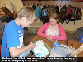
Students build their own watershedto see how surface runoff picks up everything in its path.


Students learn about cleanup methods for Hanford's 80 square miles of contaminated groundwater.


Students play Ecology's card game matching pictures of Hanford Site animals to their descriptions.


A few weeks ago, I received letters from 50 fifth graders at James McGee Elementary in Pasco. They’d been studying ecosystems, conservation and pollution, and they wanted answers about Hanford. Why is Hanford so contaminated? What is a Vit Plant? How can radiation be captured in glass?

So, on June 1st, I visited the classrooms of two teachers: Mrs. Palomarez and Mrs. Kopf. First, their students wowed me with what they’d learned about ecosystems and pollution. Too much fertilizer on lawns and crops can speed up algae growth in surface waters. Removing a species from an ecosystem impacts other life in that system. Only rain should go in the storm drain, and so on.

Then, I showed them a slideshow on the Columbia River watershed and Hanford history and cleanup. We finished our session playing Ecology’s card game matching descriptions of animals on the Hanford Site to their pictures, trying out Hanford groundwater cleanup methods on Ecology’s model, and playing Bechtel’s WTP 2020 educational video game about the Vit Plant (also known as the Waste Treatment Plant).

Continuing the conversationOne student commented that he couldn’t believe all he had to do was write a letter to get someone from Hanford to come to his class. Surprised by the power of his own words, he sincerely appreciated that someone heard his voice and took action. Some students asked if they could continue to write to me over the summer and have their parents drop off their letters on the way to work. Why not?

The Hanford community often feels like an echo chamber in which all the same voices are heard. Though a diverse chorus, we’re always hoping to get more people in on the conversation. The genuine interest these kids showed in Hanford and the health of our environment demonstrated to me that youth can engage, and intelligently at that.

Some DO stay engagedAs I was writing this, I checked Ecology’s Hanford Education & Outreach Facebook page and discovered 5 new “likes,” two of which were University of Washington students whom I met through service-learning projects. Both promoted a public meeting to fellow students and one went on to write a glossary of terms related to Hanford’s underground tank waste (I’ll be posting it soon).

Some question the ongoing benefits of educational outreach and service learning, claiming it’s a waste of time and money. But Hanford cleanup needs funding for at least another 41 years, and we need informed people to continue working on and caring about it until then and beyond. Educating today’s youth prepares them to be tomorrow’s leaders (McGee fifth graders, that means you!).

For more pictures of my visit to McGee, see our Facebook page.