Showing posts with label #Ecology. Show all posts

Thursday, January 16, 2020

Public invited to participate in early comment period for statewide biosolids general permit

The Department of Ecology’s public processes can be wide reaching, often impacting many communities or sometimes just a few people. From permitting a long-time industrial facility to measuring the environmental impacts of a project proposal, Ecology acts throughout Washington on behalf of residents to protect and enhance this remarkable state where the environment and economy go hand-in-hand.
A wastewater treatment plant in Wenatchee
Most of Washington's biosolids are created at wastewater treatment plants
like this one in Wenatchee. 

One of the processes we undertake every five years is the redevelopment of a statewide biosolids general permit. Biosolids are a product of wastewater treatment systems, rich in organic material and nutrients, and used by farmers across Washington to grow a variety of crops. With Ecology’s oversight, proper testing and application ensures this product benefits farmers and soil without leaching nutrients into surface or groundwater.

We begin the permit development process by engaging stakeholders – both the regulated community and the general public – to first answer a question and then move forward on the development of our fifth biosolids statewide general permit.

Through January 24, Ecology is asking the public to weigh in on that initial question: “Is a statewide general permit appropriate for the regulation of biosolids under state rules?”

Responses, comments, questions, and requests can be sent to:
Emily Kijowski, Department of Ecology
Solid Waste Management
P.O. Box 47600, Olympia, WA 98504-7600.

Comments must be received or postmarked no later than Jan. 24, 2020. Visit our biosolids page for more information.

What do you think?

If a member of the public believes that biosolids cannot be properly managed under a statewide general permit, they should explain their concern and how an individual permit would result in better protections for public health and the environment, or be more efficient, less burdensome, or less costly.

And it’s important to understand that this preliminary determination concerns a single question regarding the use of a general permit. This is not an opportunity to comment on requirements that should or should not be in the general permit, or on specific facilities unless the information is related to the appropriateness of the general permit approach.

Developing a statewide general permit doesn’t mean that the public would give up its right to engage Ecology on biosolids actions that must be approved individually. Our commitment to transparent, thorough, and impartial public processes would remain intact from start to finish.

Anyone who comments on this preliminary determination will automatically be added to our list of persons interested in development of a biosolids general permit. Interested parties will receive email updates and notices on opportunities to participate in and comment on the development of a biosolids statewide general permit.

-Dave Bennett, Solid Waste Management Program

Thursday, August 8, 2019

New app shows softer side of Puget Sound

Photo of bulkhead at Luhr Beach along Nisqually River delta in south Puget Sound.
Timber bulkhead at Luhr Beach along the Nisqually River delta in south Puget Sound. Photo courtesy Hugh Shipman.
We are pleased to announce we have created a new online tool showing examples of Puget Sound beaches where traditional “hard shoreline armoring” has been removed and more environmentally friendly solutions were installed.

Our new “Examples of Puget Sound Soft Shore and Armor Alternative Projects” application shows a map of Puget Sound with 29 different beachfront projects that have employed “soft” shoreline design techniques.

Users can view before-and-after photos of project sites, like the photos of Luhr Beach above and below, using the tool or by visiting our Flickr page.

Photo of Luhr Beach after log bulkhead removed and construction of new gravel beach.
Luhr Beach after log bulkhead removed and construction of new gravel beach. Photo courtesy Hugh Shipman.
The web tool is designed to spread the word about alternatives to hard armoring to homeowners, our local government partners, and anyone interested in the health of Puget Sound shorelines.

What is shoreline ‘armoring?’ 

Throughout Washington, shoreline property owners have often installed concrete bulkheads and rock revetments to help stabilize the shoreline, control erosion and protect—or “hard armor”—coastal development.
Photo of Cornet Bay in Island County with shoreline bulkhead still in place.
Cornet Bay in Island County before removing bulkhead. 
Photo courtesy Hugh Shipman
Shoreline erosion occurs naturally in Puget Sound, the nation’s second largest marine estuary. Physical process such as winds, waves, storms, tides, and plate tectonics all work to constantly shape and reshape the Sound’s 2,600 miles of marine coastline.

The majority of Puget Sound shorelines experience low to moderate levels of erosion. However, about 700 miles of marine shoreline—27 percent of the estuary’s entire coastline—currently has some type of hard armoring in place.

Most shoreline armoring was built decades before the state adopted tighter shoreline management regulations. Today, proposals for new armoring are carefully evaluated to determine if the structure is needed.

Big deal about bulkheads

While bulkheads and similar structures can reduce erosion and protect upland development from flooding, they can have serious consequences for coastal ecosystems and the long-term preservation of Puget Sound beaches.

Photo of Cornet Bay shoreline after bulkhead removed and other shoreline improvements made.
Cornet Bay after bulkhead removed, shoreline regraded, 
beach nourished, backshore vegetation planted, and anchored
wood placed on beach. Photo courtesy Hugh Shipman.
Armoring can disrupt natural patterns of sediment movement along the shoreline, resulting in erosion and the loss of the beach.

Historically, many armoring structures in Puget Sound were constructed far out onto the beach. This approach covered up backshore beach areas and disrupted shoreline ecosystem processes.

Beaches play an important role in the lives of forage fish, a key food source for salmon. Bulkheads and rock walls block forage fish from spawning on the beach, leaving fewer fish for salmon to eat.
Endangered southern resident killer whales in Puget Sound eat salmon almost exclusively, so restoring forage fish spawning grounds has impacts across the ecosystem.

These structures also limit human uses of the beach. Concrete walls make it difficult to stroll down to the beach, and climbing over sharp and slippery rock revetments can be dangerous. At some places, water comes right up to the bulkhead during high tide, leaving no room for walking.

Encouraging ‘soft’ shorelines

Nowadays, there are a variety of techniques that can be employed to “soften” the shoreline by removing rigid walls and using materials naturally found on the beach. These techniques can reduce erosion while protecting ecosystem functions.

Photo of King County's Seahurst Park before shoreline bulkhead has been removed.
Seahurst Park in King County with bulkhead in place. Photo by Hugh Shipman.
At some sites, it can be as easy as simply removing the hard armoring and letting nature take its course.

Should a site need some erosion control measures, there are several options to mimic a natural beach.
For example, fish-friendly sand and gravel can be placed on the beach—sometimes called beach nourishment—to provide extra material and elevate the shoreline.

Another approach is placing logs and woody debris on the shoreline to reduce wave energy and hold sediment on the beach. In some cases, the wood needs to be anchored in place.

The applicability of these techniques depends on the specific conditions and concerns of the site. More and more, these soft shore projects are being installed throughout the Puget Sound region.

Why softening the shoreline matters

Photo of Seahurst Park after bulkhead removed and other shoreline actions.
Seahurst Park after bulkhead removed and historic fill excavated. 
Photo courtesy Hugh Shipman.
Removing hard structures from the beach and using more environmentally-friendly erosion control techniques allows Puget Sound shorelines to return to a more natural state. When natural erosion and sediment movement are allowed to occur, beach processes and habitats are restored. Once disconnected, the forested uplands and marine ecosystems can function again in harmony.


With fewer obstacles in the way, it’s easier for all beachgoers—fish, birds, and humans alike—to make use of Puget Sound’s treasured coast.

Give us your feedback!

Let us know what you think of our new tool. To provide feedback, please use this survey link.

Tuesday, July 30, 2019

The striped nudibranch: Don’t mess with this ferocious sea slug!

Eyes Under Puget Sound’s Critter of the Month


Microscope footage of the sea slug, Armina califorica.
A striped nudibranch, Armina californica,
collected from Nisqually Reach,
Washington, March 2019.
July’s critter may be cute as a button, but don’t let the squishy sea slug face fool you. This voracious hunter strikes fear into the hearts of tiny invertebrates everywhere!

Slug of the sea

Genus: Armina; Species: Armina californica.Nudibranchs, or sea slugs, are the more elegant, marine-dwelling cousins of the slimy brown slugs you find in your garden. The striped nudibranch can get fairly large (up to 8 cm) and should be easy to spot. You won’t find one on a beach walk or tidepooling session though. They prefer the sandy or muddy seafloor anywhere from the low intertidal zone to 80 meters deep. We collect them in our Puget Sound sediment samples from Nisqually Reach, Everett, and Sinclair Inlet … often co-occurring with their favorite food, sea pens.

The pen is NOT mightier than the slug

Striped nudibranchs feed primarily on colonial animals called sea pens. In Puget Sound, their two main prey species are the orange sea pen, Ptilosarcus gurneyi and the slender sea pen, Stylatula elongata

In the southern part of their range (California to Panama), they also feed on the sea pansy, Renilla koellikeri. These species can bioluminesce, or give off light, when disturbed, so munching by sea slugs can set off a tiny underwater fireworks display!

Night terrors

Four sea slugs eating an orange sea pen.
Striped nudibranchs swarm and consume an orange sea pen until
only the white skeletal rod remains (visible in upper right corner).
Photo by Neil McDaniel.* 
Striped nudibranchs cleverly let the routine of their prey determine their activity schedule. Instead of wasting time crawling around during the day when sea pens are buried in the sand, they stay buried too, with only their rhinophores, or sensory structures, protruding. 

The rhinophores help the nudibranchs “smell” chemicals in the water that indicate food is nearby, and they can detect changes in light with a pair of tiny eyes. When night falls they emerge, searching for fleshy victims to devour. The nudibranchs use suction to ingest pieces of the sea pen’s tender polyps, pulling the tissue off and leaving only the hard white rachis, or skeleton, behind.

Microscope image of sea slug.Pretty with poison

You would think plenty of animals would be happy to give the striped nudibranch a taste of its own medicine in the predation department, but even the ravenous sun star, which eats pretty much everything in its path, gives this little nudibranch a wide berth. In fact, the striped nudibranch has very few natural predators. So, what makes this slow-moving nudibranch so unappetizing? It can incorporate chemicals from the tissue of its sea pen prey into its own body, making it toxic to consume.
The underbelly of the sea slug.
This lateral (side) view shows the groove on the right side of
the animal, with the anus to the left (posterior) and the gonopore
(reproductive opening) to the right (anterior). Image courtesy of
Dave Cowles, wallawalla.edu.

In the groove

While the striped nudibranch may be the stuff of nightmares to a sea pen, it’s a daydream for a mollusk taxonomist. Most nudibranchs are difficult to identify, but the distinct long white ridges and dark background of this species are very distinct. It has no appendages on its top surface except for the rhinophores, which project out of a notch on its head; everything else is tucked away in a groove running down the side of the animal’s body. Hidden away in these folds are flap-like gills, the anus, and the reproductive opening.

Doing it all

Like other sea slugs, striped nudibranchs are hermaphroditic (possessing both male and female sex organs). Any two individuals can mate by connecting the reproductive “ports” on the right sides of their bodies. Eggs are laid in brownish spirals, and larvae hatch out into the water column to eventually settle and become tiny striped terrors in their own right!

By: Dany Burgess & Angela Eagleston, Environmental Assessment Program


Critter of the Month

Dany and Angela out on a research vessel. Our benthic taxonomists, Dany and Angela, are scientists who identify and count the benthic (sediment-dwelling) organisms in our samples as part of the Marine Sediment Monitoring Program. We track the numbers and types of species we see in order to understand the health of Puget Sound and detect changes over time.
Dany and Angela share their discoveries by bringing us a Benthic Critter of the Month. These posts will give you a peek into the life of Puget Sound’s least-known inhabitants. We’ll share details on identification, habitat, life history, and the role each critter plays in the sediment community. Can't get enough benthos? See photos from our Eyes Under Puget Sound collection on Flickr.

This work is licensed under a Creative Commons Attribution-Noncommercial-Share Alike 4.0 License.

Thursday, June 27, 2019

Celebrate Pride! The Ornate Tube Worm sports all the colors of the rainbow

Eyes Under Puget Sound's "Critter of the Month"

June is LGBTQ+ Pride Month, and in the spirit of celebrating diversity—both invertebrate and human—we’re featuring a critter that wears its rainbow colors with pride every day of the year. Meet one of Puget Sound’s most beautiful creatures: the ornate tube worm, Diopatra ornata.

Ornate Tube Worm under the microscope.
Diopatra ornata collected from subtidal sediments at Nisqually Reach.

Breathe with me

Like many other species of polychaetes, or marine segmented worms, D. ornata has gill structures called branchiae on each segment, which help pull oxygen from the surrounding water and sediment. In D. ornata, the branchiae are distinctly spiraled and look like frilly trees or ferns running down either side of its iridescent body. The bright red color of the branchiae comes from the blood vessels inside—if you look closely at the live worm, you can see them expanding and contracting to help circulate blood throughout the body.

Family: Onuphidae, Genus: Diopatra, Species: Diopatra ornata.

Fancy digs

The “ornate” parchment-like tube of a Diopatra worm gets its name, and decorative appearance, from the bits of shells and algae attached to the hook-shaped top end, which projects from the sediment surface. Although only a few centimeters of tube are exposed above the sand, the buried portion may extend down as much as a meter!
Photo courtesy of Jeff Adams, Washington SeaGrant.

The tube’s adornments, which the worm sticks on with mucus, not only serve as camouflage from predators, but also encourage small animals to colonize the outside. In some parts of D. ornata’s range, especially off the central California coast, the tubes occur in great densities, forming mats that provide complex habitat for macroalgae (seaweed) and other animals. The little communities of organisms on the outside of the tubes may also serve as a built-in snack bar when the worms get hungry.

Left: Shell-covered tube worm protruding from the sand. Right: Shell-covered tube worm removed from the sand.

Left: A shell-covered Diopatra ornata tube protrudes from sandy sediment (photo courtesy of Kevin Lee, www.diverkevin.com). Right: This tube has been dug up, showing the bare end that stays buried in the sand (photo courtesy of Jeff Adams, Washington SeaGrant).

Jaw-dropping

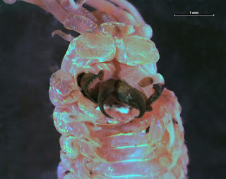
Close-up of the Ornate Tube Worm's jaws under a microscope.

Ventral (bottom) close-up of a preserved
Diopatra ornata specimen
with its jaws extended.
Scientists disagree on what D. ornata’s favorite food is—perhaps because it likes them all! It is perfectly happy munching on detritus (organic matter), but can also grab pieces of seaweed or small invertebrate prey in its rather fearsome black jaws. It has no eyes, but can sense the world with five long antennae attached to its head.

Diopatra like to build their tubes in sand rather than fine mud, so in Puget Sound, we see them most frequently where the sediment is coarse, such as around Nisqually Reach and East Anderson Island. So next time you’re walking on the beach at low tide and spot a large debris-covered tube sticking out of the sand, chances are you’ve encountered the home of one of these ornate beauties!

By Dany Burgess & Angela Eagleston, Environmental Assessment Program


Critter of the Month

Our benthic taxonomists, Dany and Angela, are scientists who identify and count the benthic (sediment-dwelling) organisms in our samples as part of our Marine Sediment Monitoring Program. We track the numbers and types of species we see in order to understand the health of Puget Sound and detect changes over time. 

Dany and Angela share their discoveries by bringing us a Benthic Critter of the Month. These posts will give you a peek into the life of Puget Sound’s least-known inhabitants. We’ll share details on identification, habitat, life history, and the role each critter plays in the sediment community. Can't get enough benthos? See photos from our Eyes Under Puget Sound collection on Flickr.

Thursday, May 9, 2019

Kicking off American Wetlands Month by securing $4.5 million in federal conservation grants

Skookum Valley wetland aquisition site in Mason County. A federal grant will help the Squaxin Island Tribe acquire, restore and permanently protect wetlands and shorelines at the site.
Skookum Valley wetland acquisition site in Mason County. We secured a $564,000 federal grant to help our Squaxin Island Tribe partner acquire, restore and permanently protect wetlands and shorelines along Skookum Creek that drains to Puget Sound. Photo courtesy Doug Ridenour.
To help celebrate Washington’s wetlands during May—American Wetlands Month—we’re delighted to share we have secured five National Coastal Wetlands Conservation grants worth $4.5 million.

This year, the federal grant program will help local partners including tribal governments and nonprofit land trusts acquire, restore, and enhance about 400 acres of coastal wetlands in Clallam, Mason, Pierce, and Thurston counties. All five projects will help recover salmon that Washington’s endangered Southern Resident orca whales depend on for survival.

The program is managed by the U.S. Fish and Wildlife Service (USFWS) and funded in part through taxes paid on equipment and fuel purchases by recreational anglers and boaters. Established in 1990, the federal conservation program provides up to $1 million for individual wetland projects in coastal and Great Lake states as well as U.S. territories.

Wetlands essential for Washington economic, environmental health

Washington’s wetlands are essential for sustaining the state’s economic and environmental health. Wetlands act as a natural sponge, helping control flooding and erosion by catching and slowing down melting snow and surface water runoff from storms. They purify water by filtering sediments and trapping excess nutrients and pollutants such as heavy metals. Wetlands also hold much of the surface water that trickles through the soil and recharges our underground drinking water aquifers.

If communities had to replace the flood control and water treatment functions Washington’s wetlands naturally provide, the costs could far outweigh the expense of preserving them. A 2008 independent study by Earth Economics found fresh water wetlands in the Puget Sound regional alone could be worth more than $10 billion to the state economy.

Productive ecosystems rivaling rain forests and coral reefs

Our wetlands also offer important refuge for wildlife and fish, including salmon, and places for people to boat, fish, and enjoy other recreation activities. Wetlands bordering or close to the marine waters of Puget Sound and Pacific Ocean can be among the most productive ecosystems in the world, rivaling rain forests and coral reefs. Wetlands also help mitigate climate change by absorbing greenhouse gases.

Although only states can apply for National Coastal Wetlands Conservation grants, we work closely with land trusts, local and tribal governments, and other entities to identify conservation projects in Washington and develop wetland restoration and protection proposals for consideration by USFWS.

Since 2008, we have helped secure federal funding and provided technical assistance for acquisition and restoration projects totaling more than $100 million to conserve more than 11,000 acres of Washington’s coastal wetlands.

This year, Ecology received 22 percent of the total $20.3 million in coastal wetlands grants USFWS awarded nationally. The Washington Department of Fish and Wildlife also received a $1 million USFWS grant to restore a coastal wetland in lower Hood Canal.

Washington’s 2019 coastal wetland conservation projects

Working with local partners, the 2019 federal grants Ecology secured will be used to help fund the following coastal wetland enhancement and restoration projects:


Baird Cove site in Thurston County. Photo courtesy Eric Erler.
Baird Cove Acquisition ($995,000)—Working in partnership with the Nisqually Land Trust to acquire an 88-acre estuarine complex in Thurston County on the east side of Johnson Point in southern Puget Sound, including more than 4,200 feet of intact estuarine shoreline, pristine coastal wetlands and mature forest.


Elwha Estuary Place site, Clallam County.
Elwha Estuary Place site, Clallam County. Photo by John Gussman.
 Elwha Estuary Place Acquisition ($1 million)—This collaborative project with the Coastal Watershed Institute will conserve historic Elwha River estuary wetlands and restore marine shoreline along the river delta in Clallam County.


Skookum Valley Wetland Acquisition ($564,000)—Working in partnership with the Squaxin Island Tribe, the funding will be used to help acquire and permanently protect 158 acres of wetlands and shorelines along Skookum Creek that flows directly to Puget Sound in Mason County.


Sound View Camp property in Pierce County.
Sound View Camp Conservation Easement ($950,000)—We are working with our Nisqually Land Trust partner to acquire a permanent conservation easement to protect Sound View Camp, a 93-acre waterfront property on Drayton Passage in southern Puget Sound in Pierce County.


West Oakland Bay restoration site in Mason County
West Oakland Bay restoration site, Mason County.
Photo courtesy Anchor Environmental.


West Oakland Bay Restoration Phase 2 ($1 million)—Working with our Squaxin Island Tribe partner to put the second phase of restoring critical coastal wetlands in place in West Oakland Bay in Mason County. The project will restore 28 acres of saltmarsh, lost when an industrial harbor was created more than a century ago.


Wetlands tools and resources 

Want to know more? We provide technical assistance and development tools for local governments, consultants, and developers regarding the responsible management, regulation, and stewardship of state wetlands.

Monday, April 29, 2019

Monitoring air quality in Washington

Did you know that April 29-May 3 is Air Quality Awareness Week? There's not much in this world that is more important than having clean air to breathe, so it makes sense to take a little time to appreciate the air around us - and the hard work that goes into keeping that air clean.

In Washington, Ecology, the U.S. Environmental Protection Agency, tribes, and local clean air agencies maintain a network of more than 90 air monitoring stations that continuously measure air pollution. Using continuous monitoring data, we can let you know when air pollution reaches unhealthy levels. Based on this information, people can adjust their daily activities to minimize unhealthy effects. That data also helps Ecology track long-term trends and identify areas where we need to do more to reduce air pollution.

National Ambient Air Quality Standards (NAAQS)

The federal Clean Air Act requires states to develop plans to monitor and reduce air pollution to protect the environment and public health. EPA sets national standards, the National Ambient Air Quality Standards, for six of the most serious air pollutants:

Air quality monitoring

We use the Washington Air Quality Advisory (WAQA) as a tool to advise people about air quality levels. The WAQA is very similar to the national levels set by the EPA, but our state standards are slightly more protective when it comes to particulate pollution - the kind of pollution that comes from wildfires and wood smoke.


Ecology and seven local clean air agencies help keep the air clean by:
  • Developing and enforcing rules about air quality.
  • Regulating harmful emissions from vehicles, burning, and industrial activities, and reducing greenhouse gases that contribute to climate change.
  • Issuing air quality permits and inspecting the businesses and industries that have those permits.
  • Tracking air quality across our state.
  • Developing plans to maintain and improve air quality.
  • Informing the public about air conditions by:
  • Educating the public about making healthy, clean air choices.

Air quality and your health

Air pollution is a harmful mix of gases and toxic particles. In Washington, the largest sources of air pollution are emissions burning fossil fuels, smoke from wildfires and heating with wood, and industrial emissions. Kids, the elderly, pregnant women, and people with existing lung or heart diseases are the most sensitive to air pollution. The health effects of air pollution are a serious matter. 

Poor air quality can cause:
  • Burning eyes
  • Runny nose
  • Coughing
  • Respiratory infections
  • Asthma attacks
  • Bronchitis
  • Chronic obstructive pulmonary disease (COPD) and lung cancer
  • Irregular heart beat
  • Heart attacks and cardiovascular disease
  • Stroke
You can protect your health by:
  • Paying attention to fire and smoke related news reports
  • Staying indoors with your windows closed
  • Setting your air conditioner to recirculate and using a HEPA filter
  • Leaving the area if possible
  • Avoiding outdoor exercise when air quality is poor
  • Consulting your doctor if your symptoms are severe.

What you can do to help reduce air pollution

Every time you drive to school, use your heater or air conditioner, clean your windows, or even style your hair, your choices affect air pollution. Follow these steps to help reduce air pollution:
  • Drive less
  • Combine errands or use public transportation
  • Switch to a zero emissions vehicle, walk, or ride a bike
  • Postpone travel until the weather cools when possible
  • Don’t let your engine idle
  • Refuel your vehicle in the early mornings
  • Don’t use lawnmowers or other small engines during heat spells
  • Don’t burn yard waste, instead try composting
  • Don’t barbecue or use your fire pit while it’s hot out
  • Follow burn bans
  • Don’t paint or use aerosol sprays until temperatures cool off
  • Replace your wood stove if it isn’t certified in Washington.
By Kim Vaughn, Air Quality communications

Friday, April 26, 2019

Chehalis River Basin Flood Authority earns national floodplain management award


Flood Authority helped construct new berm around Montesano wastewater treatment plant to protect the facility from Wynoochee River floodwaters.
In 2014, the Flood Authority helped a construct a new berm around the settling ponds at the Montesano wastewater treatment plan. During the major 2007 flood, waters from the Wynoochee river nearly overtopped the existing berm.
An essential partner helping develop and carry out the Chehalis Basin Strategy has earned a prestigious national award.
The Chehalis River Basin Flood Authority has been working with the Chehalis Basin Board and our Office of Chehalis Basin on a collection of actions to reduce damage from floods while restoring aquatic habitat in the Chehalis River basin.


Last week, the Association of State Floodplain Managers announced that the Flood Authority has earned its 2019 James Lee Witt Award for Excellence in Floodplain Management. It is only the second time in 33 years an organization in Washington has received the award.

More than 19,000 professional floodplain managers from across the country belong to the national association. Its mission is to promote education, policies and activities that mitigate current and future losses, costs and human suffering caused by flooding, and to protect the natural and beneficial functions of floodplains.

Of all natural disasters, floods and flooding are the single greatest cause of adverse social, economic and environmental impacts. Since 1971, there have been 14 federally declared disasters in the Chehalis basin from flooding.


New Sickman-Ford overflow bridge helping Oakville avoid flooding
New Sickman-Ford overflow bridge
helping Oakville avoid flooding.
 
The association recognized the Flood Authority for its outstanding and aggressive programs aimed at mitigating flood risk, reducing flood damage, and increasing flood threat awareness in the Chehalis basin—the state’s second-largest river drainage system.

“We have come a long way in 10 years,” said Grays Harbor County Commissioner Vickie Raines. “The Flood Authority has helped transform how basin governments approach floodplain management. We have gone from being reactive to being on the cutting edge.”

Raines is also a chair of the Flood Authority, which is made up of officials from the principle jurisdictions in the basin affected by flooding including Grays Harbor, Lewis and Thurston counties, and Aberdeen, Bucoda, Centralia, Chehalis, Cosmopolis, Hoquiam, Montesano, Napavine, Oakville, and Pe Ell. Other communities in the basin have also benefitted from the Flood Authority’s expertise and support.

New flood warning gauge at Montesano wastewater treatmehnt plant.
New flood warning gauge at Montesano wastewater treatment
plant next to new berm, next to nearby Wynoochee River.
When river levels rise in the basin during storms, the Flood Authority maintains a flood warning system based on real-time data from more than 80 different weather and stream gauges that alert interested parties about rising river levels. Since the 2014-15 flood season, more than 1,000 residents and businesses have signed up to receive email alerts from the Flood Authority’s flood warning system.

In addition, the Flood Authority also assisted communities in the basin improve their floodplain management programs by leading a comprehensive review of local programs and practices. This review was turned into a report that communities have used to adopt new regulatory standards that are higher than state and federal requirements.

“Locals know what works best locally,” said Edna Fund, Lewis County Commissioner and vice-chair of the Flood Authority. “We have helped retrofit homes with effective flood vents, and constructed farm pads at over 24 rural locations to save livestock, farm equipment, feed, and keep farm chemical out of the environment in times of flood. While the state has been an important partner, providing expertise, oversight and funding, it’s been a locally-driven approach that’s successfully encouraged Basin residents to be more aware, innovative, and better prepared for flooding.”

Read more about the Flood Authority’s efforts leading to receipt of this year’s award.

Besides the Flood Authority, Commissioners Raines and Fund are also members of the Chehalis Basin Board that provides long-term oversight of the Chehalis Basin Strategy. The Board is responsible for developing budget recommendations to the governor’s office to implement the strategy and is supported by our Office of Chehalis Basin.